


Artist, Creative Writer and Family Historian
Cynthia has been helping us at WuHoo Timaru get our heads around the importance of respecting peoples research, how to acknowledge it and thinking more critically when interpreting it. This is a fantastic write up about her home and how she researched it with wonderful suggestions on how you can do the same to find your own WuHoo.
I have lived in Timaru most of my life. I worked in education for over 25 years and have been interested history since a young child, particularly the ordinary and everyday lives of people and their communities. I learned a lot about local history during my time working as the first Heritage Educator at South Canterbury Museum, where I had to research and create and teach programmes and resources for students of all ages.
Your museum and library have a vast range of resources just waiting to be tapped! As well as things, there are loads of people; staff, volunteers and associated local historians who collectively have an enormous amount of knowledge who can help answer your questions or suggest research options. I have researched and written an award winning family history book, keep a blog, and currently I am working on another book.
Much of my research involves starting with individuals and trying to find where they lived, although starting with a house and working backwards follows a similar process. Many of the places I have researched no-longer exist; some seem to disappear before we realize. This is what happened in the Christchurch earthquakes, where vacant spaces appeared it was hard to remember what had been there before. So a lot of wider background reading and research is needed to understand the context of history and the community to keep memory alive: we don’t know what we have lost until it is gone.
In order to build a picture it is vital to understand the historic and cultural reasons people lived and worked where they did, although we must not assume people always had choice. Those who are well-off have better choices, while some people, like today, make-do with what they can afford in their circumstances. Houses are not always owned; people live with family, others rent, some are even homeless.
Places, houses and buildings are assigned meaning by the people who live and work in them. These places can come to life when we learn about the intersection of people, their homes and local history. Few ‘ordinary’ houses are thoroughly documented; just like ‘ordinary’ people, they tend to slip under the radar of official history, all the more reason that we should record and celebrate the commonplace.
- Cynthia McCaughan 2020
Like some help?
Cynthia McCaughan can help you research. Get in touch with her via her Facebook facebook.com/inkandstonewriting or Website: inkandstoneblog.wordpress.com
Our house, our home
 We bought 74 Grants Road, Timaru in 2004. This is the third property in Timaru I have owned, but I have lived in seven houses altogether in Timaru since 1966 we came to town[1].
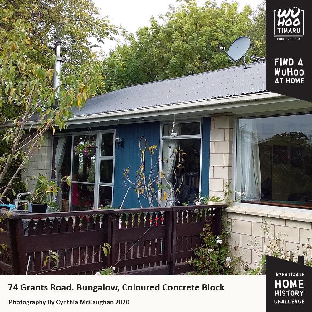
Our home is an unremarkable bungalow, coloured concrete block, iron roof, over a basement and garage at the back. The windows are aluminium, and it has a wooden deck, and on the east side, a wooden and glass conservatory. The house rarely features in photographs, occasionally we see glimpses behind family gatherings
Because it is built over a slope, the east and south sides of the house are elevated. Originally we could see the sea but that only happens in winter when the leaves on the trees are gone, but I love looking out directly into the branches of huge trees.
This house is built on a large back section with mature trees, sloping to the south and backs onto Dunkirk Street. The trees, in what we call our woodland, are mature oaks, ash, lime, walnut and plums with also a totara, lacebark and several cabbage trees and pittosporums. These attract a lot of bird life; fantails, waxeyes, grey warbler, thrush, blackbirds, swallows, the odd bell bird, kingfisher while white heron, paradise ducks, black back and grey gulls, geese and ducks often fly over. We have free range chickens which enjoy the undergrowth too. The trees were one reason we bought the house, however they date well before the 1970s.
Our house was built 1975 by builder Dave DeJoux[2] for his young family: three children grew up here (and left their mark!). There is a tree house in the garden that he built which is still standing.Dave and his daughters visited last year just before he passed away and I learnt a bit more about our house.
Dave had a carpentry workshop under the house which has since been divided into two rooms which we use as art studios. The house inside has changed a little; a hallway and front door were removed to enlarge the lounge, the door to one of the bedrooms also moved. Inside the built-in wardrobes are the remains of the original funky 70s wallpaper. The bluestone wall in our front garden was built with stone salvaged from the widening of the bridge on Old North Road, and the wooden beams which the back garden is terraced were from another bridge on Taitarakihi creek at Smithfield.
Finding out more about our place
When we bought our house, information that came with the report from the council included a plan of when the section was first sub-divided in 1955 which included the big house at 82 Grants Road, called “Wichenford”. Who owned this land?
I decided to follow some research about this estate, to confirm what I had investigated when I worked at SC Museum. Following my usual approach of searching ‘wide’ then narrowing my focus, I decided I wanted to find more about the area before my house was built. Just like researching families, it pays to look at what the neighbours are up to and to understand the local community.
Firstly I checked out the local area of Grantlea / Marchwiel and Grants Road. I looked up my copy of Streets of Timaru (1975, reprinted 2011), and also searched for (Grants Road+Timaru) on-line. This area was associated with the Grant family of Elloughton Grange, there is a lot about them on-line. South Canterbury Genweb has interesting local information. This site has a large number of pictures including aerial shots of the general area including the big house called Wichenford on Grants Road[3].
Most of the area on the south of our property was built as state housing after WWII while houses to the north are from the late 1950s-1970s. Many of these families had young children, so Grantlea School was built in 1959. A large local employer was the Smithfield Freezing works, within walking or cycle distance. There were grocery and butcher shops at the bottom of Grants Road and at Marchwiel Park. Houses had large sections for growing vegetables. State houses didn’t have garages as buses were plentiful.
 Googling (Wichenford) I found that it is a town in Worcestershire and the Washbourne family have been written about in a book. Googling (Wichenford +Timaru) gave me a real estate page which described the setting for the house as Hidden in a woodland […] boasting mature natives and exotic trees, including a kauri, totara, oaks - so this indicated that perhaps the original Wichenford owner also planted the trees on our section. Further down the same page of Google results was a link to Papers Past which showed a marriage: of Harry Waine, elder son of .Mr and. Mrs F. I. Washbourn, "Wichenford’, Timaru.
I then went directly to Papers Past to search[4]. I started with Newspapers, view date 1900- 1950, unchecked the tick box ‘select all’ then selected the region (Canterbury) and toggled so I could sort by date, 100 items per page and show preview. Searching for both Wichenford and FI Washbourn gave me most of the information on the Washbourn family and Wichenford that I needed. (Remember starting ‘wide’ and then narrowing your search will give best results).
I still didn’t have Mr Washbourn’s full name so I hopped onto New Zealand Births Deaths and Marriages online[5] and searched for the name, I quickly found that he was Francis Irvine Washbourn (1877-1951). Francis (Frank) married Lucy in 1905 and had three children, a daughter Mary (Molly) and two sons, Gordon and Harry, these are the names on the original subdivision in 1955!
I then went to Ancestry.com[6] to search for more information, checking the box ‘collection focus’ to New Zealand. I have a sub and can search family trees, so was able to find a tree with a picture of Frank and his parents. Without a sub you can also search Ancestry Library Edition with your library card[7]. I found postal directories and electoral rolls for Frank and his family that helped pinpoint where he lived and when (you can normally search these at the museum archives reading room too).
Dentist, Milkman and farmer
 Frank and Lucy Washbourn married in Nelson; where they both grew up. They came to Timaru not long afterwards. About 1906 Frank Washbourn set up a dentistry practice in Bruce’s buildings in Beswick Street. They lived at Beverley Road up until the late 1920s. Possibly around 1912, Frank had purchased farm land that ran along Grants Road[8]. Here were planted apple trees (as well as the many other trees, some of which still grace our property) and a herd of pedigree Jersey cattle. He belonged to the A & P association, the North End Ratepayers and was at one time president of the Rotary Club. At the end of the 1920s the double-storied brick house Wichenford was built and the family, then quite wealthy, often entertained guests and even rented their house out for the summer while they ‘motored’ to Nelson[9].
Your research:
- To find out more about your property Google: go to maps, and then satellite. By looking at satellite view you can see other large properties nearby, of which your section may be one part of a sub-division, like mine. You can also identify natural features such as where streams may have been; many are now culverted in Timaru. On Google maps you can put a destination in directions so you can see how far it is to places you know; friends’ houses, work, school, the park or beach. Check the date on the bottom of the image to see how recent it was. Google Street View is good if you are on a street, but our house is down a driveway hidden from view. In Street View your property number shows in a black box. At the bottom of the box is a clock symbol with an arrow, click on that and you can see the street images at earlier dates. However, Timaru District Council Property Search[10] is much clearer for satellite and aerial views, with a step back through time along the bottom. I got back to the 1930s with mine, just after Wichenford was built and before Dunkirk and Forth Streets and Goulds Road and Grantlea Drive existed.
- If you want to know details about when your house was last bought or sold and for how much, you can also see a bit for free on QV[11], the property valuation website. You also to see when other nearby properties were built. You can see historical values from 1927-2020 by using an on-line tool.[12]
- Googling your address will bring up real estate pages of houses for sale which are quite interesting as you get to nosy in other houses to see if your house is similar. Sometimes several houses were built in similar style, often by the same builder.
- Speak to older neighbours and family. Ask them what they know and remember. Record your findings and don’t forget to add the name and date of your informant.
REMEMBER: Act like an historian!
Always make a note of where and when you find information.
Just a few on-line resources for Timaru/ South Canterbury Research:
Timaru District Library; https://library.timaru.govt.nz/home
South Canterbury Museum https://museum.timaru.govt.nz/home (or other local museums: Geraldine, Waimate, Temuka) (also on Facebook)
South Canterbury Historical Society: https://historicplacesaotearoa.org.nz/tag/the-south-canterbury-historical-society/
South Canterbury, NZ Society of Genealogists https://www.genealogy.org.nz/South_Canterbury_176.aspx (also on Facebook)
Teara: places, biographies https://teara.govt.nz
Archives NZ, Archway portal: https://www.archway.archives.govt.nz/
National Library of New Zealand: https://natlib.govt.nz/ see also https://paperspast.natlib.govt.nz/newspapers
NZETC http://nzetc.victoria.ac.nz/tm/scholarly/tei-TayLore-t1-body1-d10.html
NZhistory online https://nzhistory.govt.nz/keyword/timaru includes state housing
Timaru History and Memories Face Book group https://www.facebook.com/groups/376136849115788/
Further things to do
- Make a plan of your house. Are there additions or extensions? Can you discover old paint colours or paper? (look inside cupboards and wardrobes). What do you love about your house? What would you change if you could?
- Map your garden. Personalise it by adding things like sheds, the chicken run or dog kennel, best spot for sun, special trees or plants, swings, hidey holes, where the cat likes to sleep.
- Map your neighbourhood. Draw things that interest you. Measure how many paces to favourite features, eg crooked tree, funny letterbox, bridge where you see the ducks, playground, school. Mark where things happened (“Fell off my bike here”): See similar maps online (Google these: Wind in the Willows map, Milly Molly Mandy Village)[13].
- Create a timeline for your house. What was happening in local, national and global history at the same time?
- Research the original owner and write up a history folder, or share a post on-line (eg Face Book group, Timaru History and Memories). If your house has been in the family a long time, you might want to start a page or group on Facebook for other family members to contribute to.
- Frame photos of your house or the original owner and display in your home:
- Make a painting or drawing of your house
- Make a time capsule and hide it (under the floor, in a cupboard or in the ceiling for future owners)
- Paint (build or add to) your letterbox to reflect your house and its occupants.
Footnotes:
[1]I was born in Wyndham, Southland, moved to Tripp Settlement Road, Geraldine in 1963, then to Pleasant Point in 1965. Both my other houses were character Bay Villas. How did I end up in a block box? It is private, warm, and full of light, plus room for studio space. I do miss having a wide hallway and wall-space to display art though.
[2] ( 1951- 2019) David was elected president of Central South Island Fish and Game Council in 2018. See https://fishandgame.org.nz/assets/Uploads/FGNZ-2018-Central-South-Island-Candidate-profiles-v3-007.pdf
[3] https://sites.rootsweb.com/~nzlscant/Grant.htm
[4] https://paperspast.natlib.govt.nz/newspapers
[5]https://www.bdmhistoricalrecords.dia.govt.nz/search
[6]https://www.ancestry.com/search/
[7]During lockdown. You normally have to go into the library to do sohttps://library.timaru.govt.nz/digital-resources/featured-database
[8]See sale of land in the Township of Marchwiel 1912 Facebook post by Cherie Fagan June 4 2018 “land for sale in the northern boundaries”
[9]all mentioned in Timaru Herald on Papers Past
[10] https://www.timaru.govt.nz/services/rates-and-property/property-search
[12]https://www.inflationtool.com/new-zealand-dollar
[13] For teachers and adults read more at https://superflux.in/index.php/cartographies-of-imagination/#


