150km, round trip.
3hrs. Allow half a day to explore
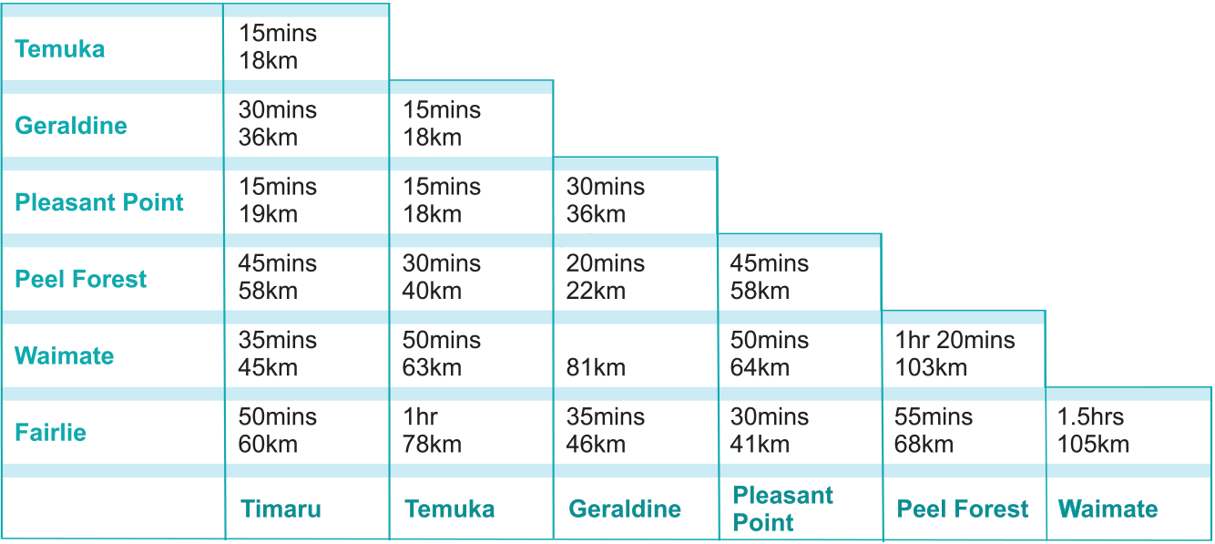
The Pioneer Trail leads you through some the the rolling South Canterbury hills. It follows a circuit from Pleasant Point to Temuka to Geraldine back to Pleasant Point. A site route leads to the forest service of Peel Forest. The site of aviation pioneer Richard Pearse's test flight is on the route.
South Canterbury's early settlers found tough conditions in their new home but were more than equal to the task. This trail testifies to the ingenuity displayed by the pioneers in their new environment.
Commencing at Pleasant Point, travel in a clockwise direction to come to the first site, the Richard Pearse Memorial. The rest of the sites are easily located by following the sign posts en route. The trail can be joined at places like Geraldine and Temuka, bringing you back to your starting point.
Richard Pearse Memorial Richard Pearse, a farmer's son with little formal education, designed and flew the first aircraft in New Zealand and possibly the world. Uncertainty remains as to when precisely he flew between the years 1902-1906. There were a number of witnesses to his first flights, but local records that could have confirmed the dates were destroyed by fire. It is believed his aircraft came to rest on top of a gorse hedge and was covered by a heavy snow storm. The snow storm is thought to be July 1903 - before the Wright Brothers flew. A replica of his aircraft is by the roadside. Relics of early aviation that were designed and manufactured by Richard Pearse, are displayed in the Pleasant Point Railway Museum, as well as the Auckland Museum of Transport and Technology.
Waitohi Hills offers all-round, magnificent views. Many of the gullies passe don the road were used as sites by illicit whisky distillers. This route is unsealed. Once on the flat, travel straight ahead on the Winchester/Hanging Rock Road to Kakahu School, before returning to Hall Road and the Lime Kiln site.
Kakahu School The Kakahu school was built in 1884. It is here that Jessie Mackay taught from 1887 to 1890. Jessie Mackay is recognised as an important poet and a leading suffragette who worked with Kate Sheppard in securing the vote for women in 1893. "No other New Zealand poet has reached her height of vision, or sung with her intensity of feeling" (Anderson 1916). Bullocky Jones' children went to school here.
Kakahu Lime Kiln (1881) This kiln could be described as "Norman" in style and built of marble and limestone. Limestone from the top of the hill was run along tram lines to the kiln , where it was put in layers between firewood and burned. The burnt lime was used in buildings and for agriculture. The kiln is one of the area's oldest industrial relics.
St Anne's Church (1861) Found in Pleasant Valley, which runs off the main highway between Geraldine and Fairlie, St Anne's Church is one of the oldest wooden churches in the Christchurch Diocese still standing on its original site and in its original form. Built in 1865 it was the second church in South Canterbury. The first was the original wooden St Mary's Church built in Timaru in. This church was replaced by the old bluestone building that still stands in Timaru's centre today.
Talbot Forest sits above Geraldine township. Geraldine was established as a saw milling town and Talbot Forest Scenic Reserve is the last remnant of the extensive forest that grew in the Geraldine area at the time of European settlement. The reserve offers some easy shady walks and the opportunity to reflect on this community of native plants, from the big old forest giants, totara, kahikatea and matai, to the ferns and seedlings on the forest floor. Both native and introduced birds fill the forest with song. The trail leads onto State Highway 79 and here you may choose to turn left to carry on to Peel Forest, or turn right into Geraldine township and continue on the Pioneer Trail circuit. The trip to Peel Forest takes approximately 30 minutes.
Peel Forest The forest is a remnant of mixed podocarp-hardwood rain forest. The podocarps (kahikatea, totara, matai) and the big trees and, where plentiful, form an upper canopy. Many broadleaved-hardwood trees are present and with climbing plants form a second canopy which screens most direct sunlight from the forest interior. Below is a further layer of less light-demanding trees and shrubs, followed by the ground layer of ferns, mosses, fungi and tree seedlings. A mature forest of this type relies on many things for continued survival. Native birds for example are important for seed dispersal and insect control. A stable climate with ample rainfall is essential. The generally slow-growing native species face stiff competition for space from the fast-growing exotic trees, sycamore, ash and the climbing Clematis Vitalba (Old Man's Beard). Continuous control of these and of introduced animals is needed. Despite these intrusions the forest is not unlike that seen by the first European settlers some 130 years ago.
Geraldine This attractive rural service town was originally established din 1856. Logging and milling of the surrounding native forest was the main reason for its establishment and timber was in demand for the development of Timaru. Bullock wagons carted timber from the pit mills.
Geraldine Vintage Transport Museum The Geraldine Vintage Transport Museum can be found on Talbot Street, on kilometre south of the town's Post Office. It contains a wealth of information and displays of vintage cars and machinery. There are over 30 vintage and veteran cars dating as far back as 1905, about 90 tractors from 1912 onwards, including the oldest working tractor in New Zealand, and a variety of old farm equipment. Also on display is New Zealand's only surviving 1929 Spartan bi-plane. The museum is open by request only during the winter, and from Labour Weekend until Queen's Birthday Weekend, from 10am-midday and from 1.30pm-4pm.
Temuka functions as a service town for the surrounding rural area. Its main industry is the manufacture of ceramic wares from local clays. It is the home of Temuka Pottery, renowned for its design and quality. Prior to European settlement, the Temuka area was occupied by Maori. The name Temuka is a derivation of Te Uma Kaha, which means 'the stong oven' and is associated with the many Maori earth ovens found in the district. When the northern Maori raided the South Island in the 1820's, the palisaded Te Waiateruati pa, sited to the east of the present day Temuka, stood firm and provided the base for their repulsion. Tuhawaiki, the paramount chief of the large Ngai Tahu tribe, led this counter attack. Temuka remains an important area for Maori to this day. The Arowhenua Marae lies to the south of Temuka between the Temuka and Opihi Rivers.
Temuka main street has many examples of Edwardian architecture. A good example is the building which houses the Temuka Information Centre. From here the trail returns you to the Richard Pearse Memorial. If you have already visited this site you may wish to finish the trail at this point.