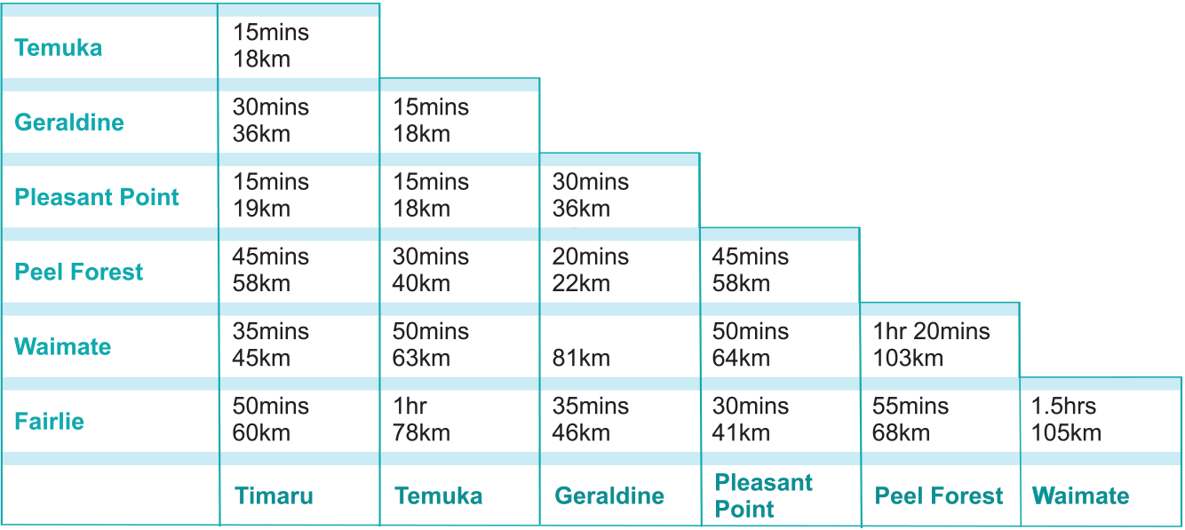


150km one way
3hrs. Allow half a day to explore
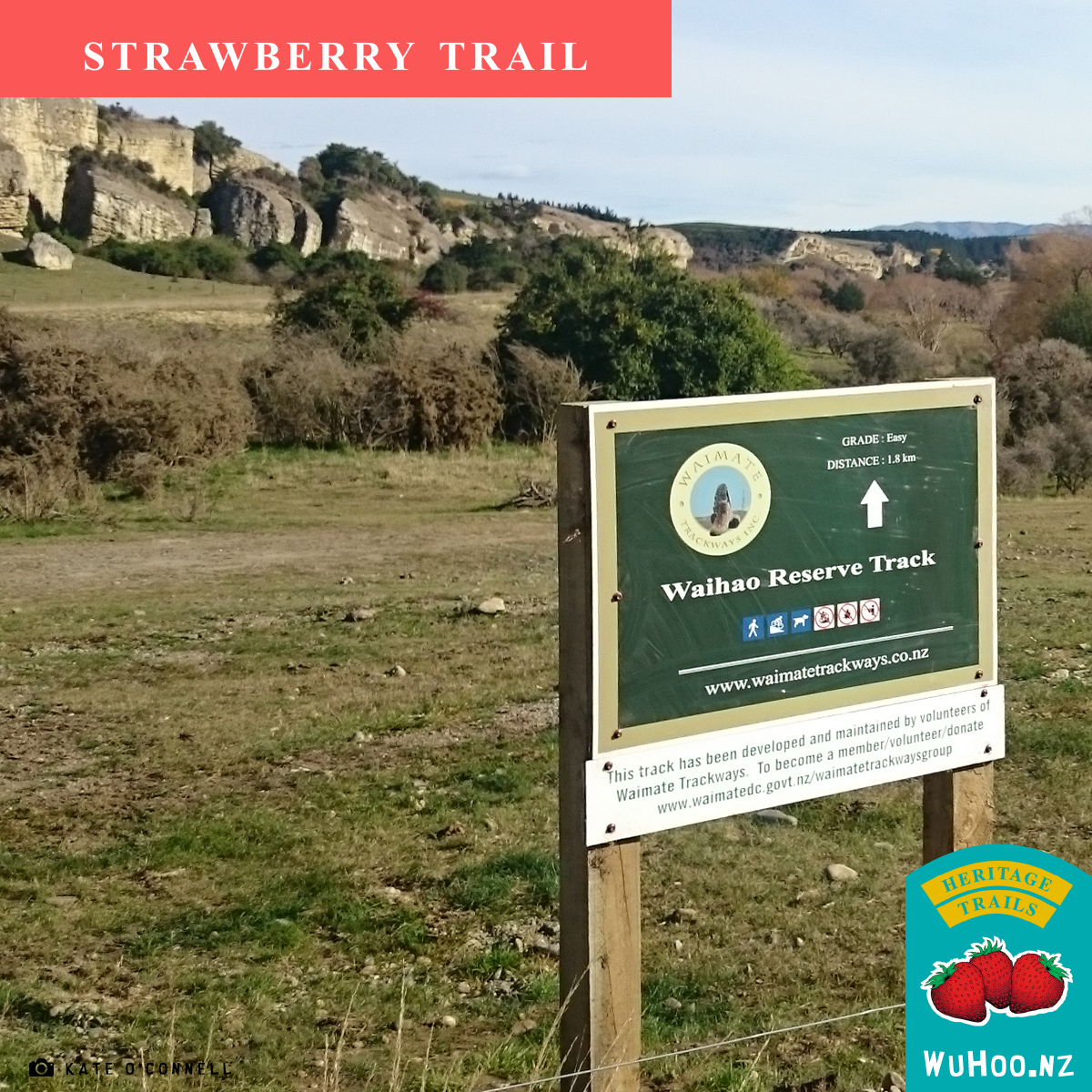
The Strawberry Trail leads you through the Waimate area renowned for it's strawberries. It leads you from Timaru to Kurow or vice versa. Along the route you can visit the coastal area and the Wianono Lagoon wildlife sanctuary. You can climb above the plains for an expansive view of the South Canterbury. You can visit historic buildings, parks and walkways.
The Waimate District is an area renowned for its succulent strawberries. This trail leads right to the heart of strawberry country, and during the months of late November to May, punnets of the freshly-picked fruit, are sold at roadside stalls. The main concentration of strawberry fields is found on the road leading north out of Waimate to State Highway 1 and Timaru. The main course of the trail takes travelers eastward out of Waimate via the historical sites of the Grand National Monument, the Waihao Box and Bishop Selwyn's Memorial, but it is an easy drive to double back - and the strawberries are definitely worth the deviation.
The Strawberry Trail begins at the Landing Services Building in Timaru.
Landing Services Building The last remaining building of its type in the Southern Hemisphere is built of solidified lava (bluestone) on the shoreline of the old Timaru beach from which surf boats transported cargo to and from sailing ships lying off-shore. Built about 1870, boats were winched over the shingle beach into the building for loading and unloading. This service was made redundant by the arrival of the railway (1875) and the construction of the breakwater (1879). The land across the railway, now covered by industrial buildings, was built up of seaborne rocks and shingle trapped behind the breakwater, while the finer sand was carried past the port to form and extend the famous Caroline Bay. The bullock wagons loaded and unloaded at the Landing Service. Departing Timaru, follow State Highway 1 South, to continue on the trail.
Tūhawaiki Monument Just south of Timaru is Jacks Point named after Tūhawaiki, paramount chief of the Kati Mamoe and Kai Tahu Maori tribes. Tūhawaiki's nickname was "Bloody Jack" from his frequent use of the word "bloody". Tūhawaikiwas drowned at Jacks Point. The memorial, on Scarborough Road, is by his Kai Tahu descendants. From the monument it is a short trip to the coast to view Timaru and Jacks Point.
New Zealand Australian Land Company Granary At the entrance to St Andrew's between the railway line and the sea, stands the roofless remains of a concrete granary. The granary was built in 1878 on the Pareora Estate to store grain before freighting by rail to Timaru and points beyond. After Makikihi and before the Hook River, look for the left turn which takes you down to the coast. Parts of this road are unsealed.
Bishop Selwyn/Surveyor Shortland Monument Found on the Lower Hook Beach, a small rock cairn commemorates the meeting place of Bishop Selwyn and Edward Shortland, the sub-protector or Aborigines. At this spot, on January 16, 1844, the parties camped the night. A short walk along the coast from here lies the Wainono Lagoon Conservation Area. This area covers anything between 170 hectares during low-water levels, to 450 hectares when the water is high. It is one of the few lake-and-mudflat areas, remaining on the coast, and as such, is of vital importance to the many birds which either live here, or come to visit on their migratory flights. Return to State Highway 1 and continue south beyond Studholme. Look for the left turn. Parts of this road are unsealed.
First Grand National A stone cairn at Willowbridge (corner Bradshaws and Willowbridge roads) marks the site of New Zealand's first Grand National Steeplechase, held on May 18, 1875.
Waihao Box Commonly known as the Waihao Box, this is a heavily-timbered box culvert that was built to provide the Wainono Drainage Scheme and Waihao River with a permanent channel to the sea through the gravel beach. The trail leads back to State Highway 1. Turn right onto the highway then left to Waimate.
Waimate was established around the forests of the area as a saw milling town. It is now a rural service town, with a population of around 3000.
The Waimate Museum is housed in what was the Waimate Court House. It was built in 1879 and served as a court house for 100 years. The building is said to be one of the finest small-town buildings in the country. The magistrate's bench still remains among many other interesting displays. In the grounds of the museum are a cob cottage and a two-room cottage built of pit-sawn totara.
Victoria Park Located in central Waimate, Victoria Park is a favourite stopping place for visitors and locals alike. As well as boasting an impressive display of oak trees planted around the turn of the century, the park also has an enclosure where a mix of wallabies, deer, pea fowl, canaries, budgies and kea can be viewed. The park has an arena in which athletics competitions are held, as well as cycling events, soccer and occasionally hockey matches. Surrounding the arena is a large rock wall that was built during the "Depression" by the local unemployed. The wall was constructed by hand with the rocks laboriously carted from the nearby Waimate Gorge. Victoria Park runs off Queen Street, Waimate's main thoroughfare, through to Tennant Street. Follow the signs west along Mill Road, on to Point Bush Road and Parkers Bush Road. Turn left on to Centrewood Park Road, which leads to the summit.
Waihao River Walkway This river walkway follows the old railway branch line which ran through Waimate as far as Waihao Forks. The walkway travels along the south side of the Waihao River gorge for 5km. The river cuts through limestone providing a rugged and picturesque setting.
Return to State Highway 82 and continue south towards the Waitaki River
Stone Wall Built from large stones, to confine the road, the wall runs for several kilometres along the banks of the Waitaki River. It was constructed under labour work schemes during the 1930's years of "Depression". An excellent fishing spot.
Paterson's Cottage Early European settlers and gold diggers travelling in bullock wagons and horse-drawn coaches left legacies of their migration. On the north bank, where State Highway 82 meets the Penticotico River, is Paterson's accommodation house, built in 1872.
Waitaki Bridge, Kurow This bridge provides a crucial link between the north and south sides of the Waitaki River. Built in 1893, of hardwood timber, it has remained intact (with the necessary repairs) despite the ravages caused by the occasional raging torrent of the Waitaki River, and from fire.
The Strawberry Trail ends as you cross the Kurow Bridge. To connect with the Bullock Wagon Trail continue inland to Twizel.