By Roselyn Fauth

Timaru Flour Mills 1972_Tiaki Ref Num WA-70626-F-PA-Group-00080 Whites Aviation Ltd Photographs
I started this as a simple history hunt about railways... I have been curious why we put all our industrial areas on our stunning coastline... and the railway is for many of us seen as in the way... well, back in the day, they were thinking differently, they were looking for flat land, easy connection and exchange... not really about where people might like to have their abode.
The railway as I have learned while writing this blog has been a big part of Timrau's development, helping our forebears decide where buildings went, how goods moved, which parts of town became industrial, and how South Canterbury connected to the wider world. It also left us with questions about planning, land use, coastal change and the price of progress.
Stand near Timaru’s port today and the clues to that journey are still there... the Main South Line, old industrial and heritage buildings, sidings, port land, the log yard, containers, warehouses and roads all pressed close together. It is not the prettiest part of town, but it might be one of the most honest. This is where Timaru worked, it was our hub of exchange.

Atlas building by the railway line - Photogoraphy Roselyn Fauth Before frozen meat, before motorways, and before Timaru’s harbour was fully formed, grain helped build South Canterbury, which became one of New Zealand’s great grain districts, and Timaru stood at the centre of it. Category 2 Heritage Building, built in the 1880s on Turnbull Street, Timaru, designed by Dunedin architect, James Hislop. The Evans’ Atlas Flourmill was built beside the railway yard and close to Timaru’s waterfront so wheat could be brought in, stored, milled and sent out efficiently from the centre of the district’s grain trade.
Before the railway, distance was a much bigger problem.
Travel between Christchurch and Timaru could take two days by coach. When through railway communication opened between Christchurch and Timaru in February 1876, the journey could be made in six or seven hours. That was not just faster travel. It changed what was possible... we could go further than the journey a horse could manage.
New Zealand’s first steam powered public railway opened in 1863 between Christchurch and Ferrymead. Early Canterbury lines used a broad gauge, but the national railway system later settled on the narrower 3 ft 6 in gauge because it was cheaper and quicker to build through difficult country. Then came Julius Vogel’s public works and immigration programme of the 1870s. In 1870, New Zealand had about 74 kilometres of railway. By 1880, it had about 2,000 kilometres.
That wider national story matters gives our local Timaru story some context, and that our network was not developing in isolation, it was part of the bigger plan. Railways were promoted as progress, and they certainly brought speed, trade and connection. But they were also part of a colonial infrastructure project that opened land, moved resources, strengthened central government and supported Pākehā settlement.
Maybe this history tells us that transport decisions defined who connected, what became valuable, and how our town and region grew.

Bruce’s Mill - Photography Roselyn Fauth 2026

Royal Flouring Mills, James Bruce & Co. Millers & Grain Merchants. Royal Flouring Mills. Hocken Digital Collections, accessed 17/04/2025, https://hocken.recollect.co.nz/nodes/view/23535
For us, I think the best place to start the story is with Timaru’s public railway ceremony.
On 4 October 1871, Mrs Cain, Mayoress of Timaru, turned the first sod for the Temuka to Timaru section of the planned South Island main trunk railway. Captain Henry Cain, Mayor of Timaru, stood nearby. This is one of my favourite Timaru fun facts, as I would assume it was men who stood at the beginning of Timaru’s railway future, but in actual fact it was a woman with the spade.
By 1878, the Christchurch to Dunedin main trunk railway was complete. In 1879, Christchurch and Invercargill were connected by rail. Timaru now sat on a long transport spine running down the eastern South Island.
For Timaru, the key relationship was always rail and harbour. The town’s prosperity depended on moving wool, grain, coal, livestock, flour, timber, machinery and supplies between farms, stores, mills, yards and ships. An 1882 image of Timaru’s railway yards near the harbour shows a shunting locomotive, sheds, the second railway station under construction and the early breakwater. Timaru was being organised around movement... trade.

ABOVE: Group at Timaru for the the turning of the first sod on the top of the cliff off Le Crens Terrace for the Timaru-Temuka section of the South Island Main Truck Railway, (on the Christchurch-Timaru line). Mrs Cain holds the spade. Captain Henry Cain, the mayor of Timaru, stands alongside. Photographed by Mr Price 4 October 1871. Newspapers reported that there ‘was a large crowd present and the day was generally observed as a holiday’. First sod and ‘last spike’ ceremonies, celebrating the commencement and completion of railway projects, were major social and community events in the later 19th century. National Library 1/2-020116-F Learn more here and an account was in the Timaru Herald here
Now... this is where the built heritage story gets interesting.
Large industrial buildings gathered close to the railway line because that was where the work could happen. Goods needed yards, loading points, storage, sidings and quick access to the port. In that world, a building’s value was not only in its frontage or decoration. It was in how well it could move things in and out.
This helps explain why some of Timaru’s most important industrial heritage sits near the railway and port. The former Canterbury Farmers’ Co-operative Association wool and grain stores, Evans Atlas Flour Milling Company buildings, Belford Flour Mills, Timaru Milling Company buildings, J. R. Bruce’s Dominion Roller Flour Mills and Biscuit Factory, and the D. C. Turnbull and Miles Archer stores all belong to this working landscape.
The former McRae’s Stone Store makes that especially clear. Its 1876 addition was built to accommodate rails through the centre of the building. That is not just a building beside the railway. That is a building physically shaped by rail.
The D. C. Turnbull and Miles Archer site adds another layer. Its tramway tunnel and private railway siding linked merchant stores with the movement of wool, grain, coal and produce. The heritage value is not only in the brickwork. It is in the whole machine: tunnel, siding, warehouse, office, port, labour and trade.

Rail in many ways also rearranged the town.
The former Customhouse heritage record notes that an earlier customs building near the breakwater had to be removed to make way for the railway. Later, Timaru’s railway yards were criticised as cramped and inadequate. In 1913, James Craigie MP raised concerns about Timaru Railway Station, including passenger facilities and the Strathallan Street crossing being blocked on the route to wool and grain stores and the goods shed. In 1940, railway yard and locomotive depot improvements required major earthworks, including removal of a bank containing 27,000 cubic yards of material.
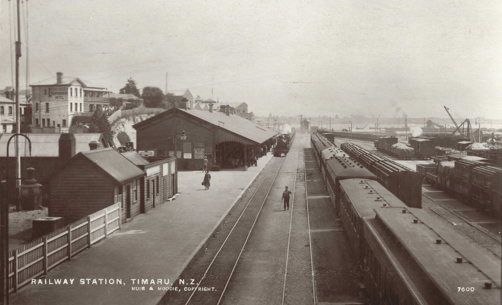
Railway Station Timaru early 1912 (or perhaps late 1911).

Timaru Railway Station. Radcliffe, Frederick George, 1863-1923 : New Zealand post card negatives. Ref: 1/2-006877-G. Alexander Turnbull Library, Wellington, New Zealand. /records/23012525
So was the railway well planned?
Well... yes-ish... depends who you talk to... For nineteenth century freight, yes. It made sense to place the line close to the harbour, commercial stores and workable ground. Rail shortened distance and helped merchants use sidings. It linked inland production to coastal shipping. It helped Timaru become an export town.
Don't forget we also forged our way powered by coal at one point, so the rail also brought us our power source from the west coast.
But good planning for one century can create problems for another and the railway and port helped claim many of the flat, practical sites near the sea for industry.
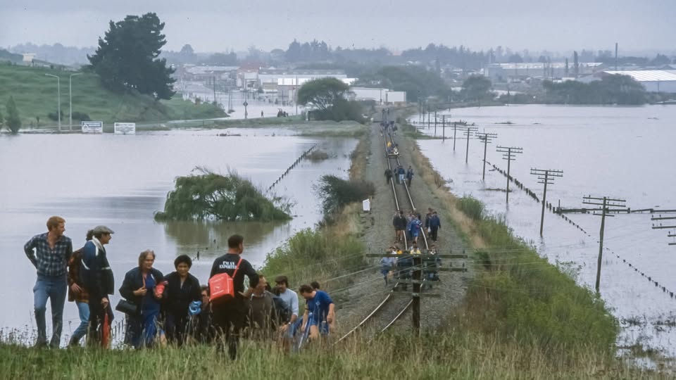
Flooding at Waitarakao Washydyke Lagoon around the railway line. Photography by Geoff Cloake.
Freezing Works, Timaru, Washdyke Lagoon. Oct 1956. Whites Aviation Collection, Alexander Turnbull Library WA-42377-F

1920-1940 J R Bruce's Dominion Roller Flour Mill, Timaru. South Canterbury Museum https://digitalnz.org/records/42256850
That raises a civic question: did Timaru trade some coastal amenity for export efficiency?
I have not found valuation rolls proving that railway-side land rose in value, or direct resident complaints about lost sea views. But the pattern is clear... businesses advertised private sidings as a commercial advantage. Buildings were designed around rail access. The port-industrial area still sits on the seaward side of the Main South Line. The railway helped create a working edge between parts of the town and the sea. I can only assume by the buildings that dot our rail line today, that a section on the rail was of logistic value.
Maybe this history tells us that the character of a town is often made by practical decisions. Put the rail near the port. Put the stores near the rail. Put the mills where goods can move. Over time, those choices become streetscapes, property boundaries, habits, blind spots and heritage.
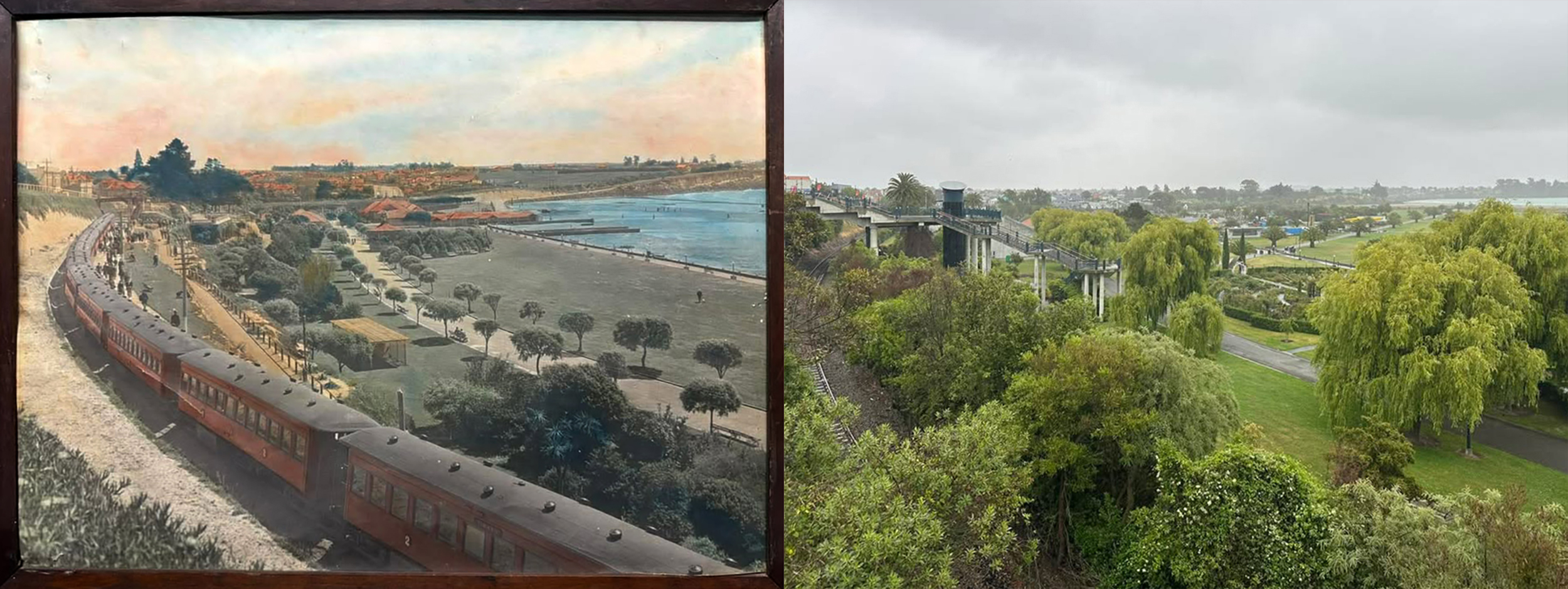
A lovely WuHoo follower flicked me a message today to share an image currently on display at the Pleasant Point Railway Museum. Alongside it was their own photo, taken while trying to find the same viewpoint today. They were happy for me to share the story, but wished to remain anonymous. Here are two scenes same spot, then and now of the rail at the bay.

Canterbury Maps 1935-39
The coast itself was also changed as Timaru’s harbour works altered the movement of shingle.
Land accumulated south of the harbour and was used for grain and wool stores and oil tanks. North of the harbour, sand built up to form Caroline Bay. One side became a working port edge. The other became a recreational beach.
But the sea kept its own account, and in 1880, Colonial Marine Engineer John Blackett reported that damage to the railway line north of Timaru harbour works was largely due to the breakwater interrupting natural coastal movement. Modern coastal assessments still identify Timaru’s port, road and rail networks, industrial areas and shoreline protection works as part of the district’s coastal hazard landscape. More recently, high seas have threatened parts of the main rail line south of Timaru, especially around the Patiti Point to Jacks Point area.
Maybe some assumed at the time that infrastructure decisions finished when the first trains arrived, but we know today, that they needed maintaince, repairs, defence and rethought.

Queen Elizabeth II poses on the observation platform of her royal car at Timaru on 25 January 1954. In the background stand the mayor and other local officials.poses on the observation platform of her royal car at Timaru on 25 January 1954. In the background stand the mayor and other local officials. - nzhistory.govt.nz/queen-elizabeth-at-timaru
The railway’s reach went inland and the Fairlie branch left the Main South Line at Washdyke and reached Pleasant Point in 1875.
Pleasant Point became the temporary terminus before the line pushed further inland. It eventually reached Eversley, beyond Fairlie, in 1884. The line carried wool, grain, livestock, passengers and mail, and the Fairlie Flyer became part of South Canterbury folklore.
The Waimate branch followed a similar pattern. The line from Studholme Junction to Waimate opened in 1877 and was extended to Waihao Downs in 1883. These branch lines shaped rural townships, market access and everyday life. Pleasant Point, Cave, Albury, Fairlie, Waimate and Waihao Downs were tied more closely to Timaru, the port and national markets because of rail.
Then roads improved. Trucks, buses and private cars changed the economics of rural rail. The Fairlie branch closed in 1968. For many people, that marked the end of an everyday railway world of mixed trains, stationmasters, parcels, livestock, mail and school trips.
Pleasant Point became the exception because local people chose to save part of their history. After the branch closed, the Pleasant Point Railway and Historical Society preserved the railway site, station, signal box, locomotives and railway memory. Its museum railway is not just nostalgia. It is working evidence of how rail once shaped ordinary life. I have met a few confused tourists who couldn't understand why we had a train in Pleasant Point that couldn't bring them to Timaru haha!
Timaru’s passenger rail story moved into a new chapter in 2002, when the Southerner, the Christchurch to Invercargill passenger express, made its final journey. The rail did not disappear, but it evolved and changed job.
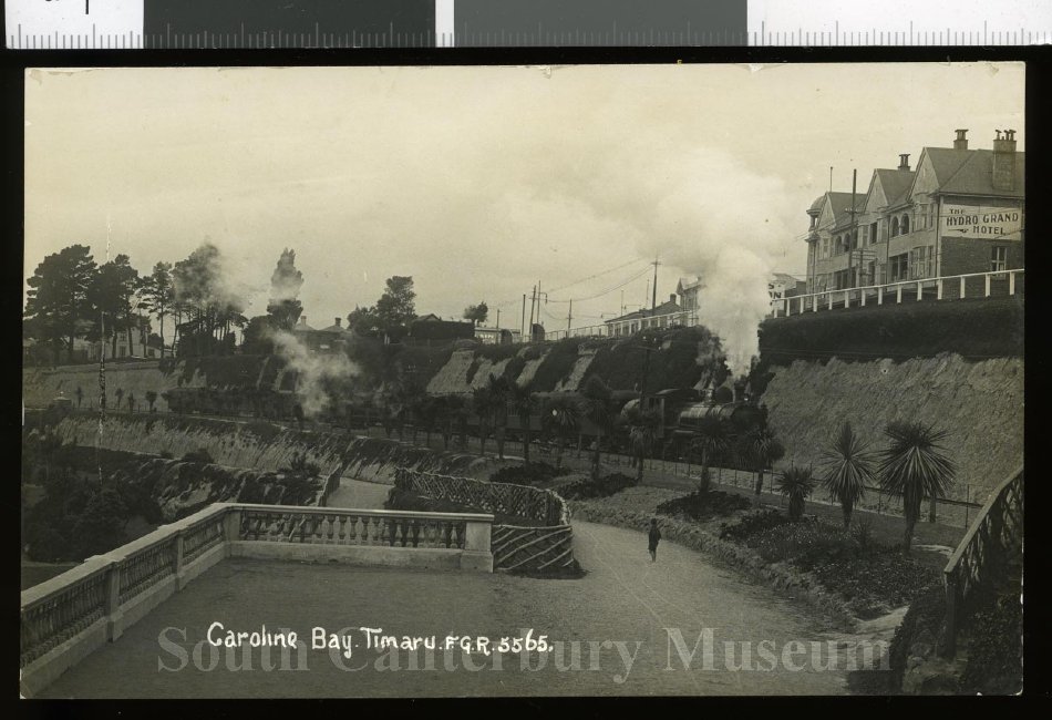
This photo is from a postcard featuring an image of the north-bound express train passing Caroline Bay, sometime between late 1915 and 1920. Taken from the Piazza looking southward at the oncoming train. The skyline features the Hydro Grand hotel (right) and the Dominion Hotel (obscured by steam). I remember someone telling me they have a memory as a young child going to the Bay to pick up their father who had returned from war. South Canterbury Museum 2011/037.32
Today, Timaru remains part of New Zealand’s freight rail network.
KiwiRail lists Timaru as a container transfer site. Timaru’s rail depot and shunting yards sit beside the port and Port Loop Road, with rail sidings into the North Mole Container Terminal and PrimePort Log Yard. Timaru Container Terminal continues that long relationship between port, rail and regional freight.
In the nineteenth century, rail helped move wool, grain, coal, flour and livestock. Today it helps move containers, logs and freight.
The question is still the same though: how does this region connect what it produces and imports with the wider world?
Maybe this rail history helps to remind us that civic identity can also found in the practical places where people solved problems: beside the tracks and on the coast where the sea still tests decisions made generations ago.
Timaru’s railways were lines of ambition. They ran from inland paddocks to port sidings, from Mrs Cain’s spade to the Fairlie Flyer, from wool stores to containers.
Our rail network helped build the town we inherited and reminds us to look harder at the built landscape around us.
Sometimes of our most important history stories are hiding in the working parts of town. and when we know the stories, we know where we have come from, and better know who we are.
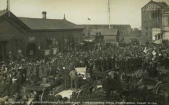
DEPARTURE OF 7TH SOUTH CANTERBURY N.Z. CONTINGENT. EXPEDITIONARY FORCE FROM TIMARU. AUGUST 24, 1914 When King George V declared war on Germany, he did so on behalf of the entire British Empire. The New Zealand Government responded quickly by assembling an initial force of 8,500 men to form the NZEF (New Zealand Expeditionary Force) to aid the Empire. South Canterbury Museum https://museum.timaru.govt.nz/explore/online-exhibits/enduring-the-inferno-south-canterbury-and-the-first-world-war/1914-south-canterbury-at-war

The Timaru Customs House. Neoclassical Building by architect Daniel West. Exterior view of the Custom House at Timaru, on the corner of Cains Terrace and Strathallan Street, photographed circa 1902. Shows a stone building in a neoclassical style, with two pairs of columns framing the entrance Alexander Turnbull Library, Wellington, New Zealand. The building was beside the railway and the port. Tiaki12044242-F

Belford Flour Mills and Timaru’s Oldest Surviving Mill- Photography By Roselyn Fauth
1878 Flour Mills
1878 Belfield Steam Flour Mill at south end of North Street. In 1881 the Evans Atlas Flour Mill built on George Street. Ad of the time listed it as producing flour unequalled anywhere in the colony. Most modern roller flour dressing machinery in the world. http://sites.rootsweb.com/~nzlscant/mills.htm 1870s South Canterbury became a major wheat producer. Production peaked in the early 1900s. https://teara.govt.nz/en/photograph/11400/harvesting-wheat
Royal Flouring Mills, James Bruce & Co. Millers & Grain Merchants. Royal Flouring Mills. Hocken Digital Collections, accessed 17/04/2025, https://hocken.recollect.co.nz/nodes/view/23535

Evans and Company billhead (31 May 1898). Hocken Digital Collections, accessed 17/04/2025, https://hocken.recollect.co.nz/nodes/view/61627
Timaru Flour Mills 1972_Tiaki Ref Num WA-70626-F-PA-Group-00080 Whites Aviation Ltd Photographs
1920-1940 J R Bruce's Dominion Roller Flour Mill, Timaru. South Canterbury Museum https://digitalnz.org/records/42256850

Evans' Atlas Roller Milling Co, Timaru 1900-1960 South Canterbury Musuem 1999/143.5 https://timdc.pastperfectonline.com/Photo/430E06E5-7F27-4A08-8E0B-423042889920

Flour-Mill-Evans Atlas Roller Flour Milling Company Timaru NZ South-Canterbury-Museum South Canterbury Museum 2775 https://timdc.pastperfectonline.com/Photo/2DD35BC5-C13B-4F47-8B9E-432827104143 A mounted photograph entitled "Evans' Atlas Roller Flour Milling Company, Timaru, N.Z", circa 1892. Shows the grain storage area to the south of the mill (in the background) prior to the second grain store being built in 1897. The grain is shown stored in a long open fronted shed which is almost full with sacks of grain. Several men are standing in front of the shed and to the right is the Evans' Atlas building. In front of the building is the locomotive 'A' 68 linked to wagons also loaded with grain.

Timaru from the dome of the RC Church, looking east. The left side of the image is bordered by Heaton Street, while Browne Street cuts in diagonally from the left side. Across the foreground runs Rose Street. In the foreground part of the Marist Brothers School is visible (with the crosses on the roof line), while the building to the right and behind the hedge may be the school building which was used as a church, when the previous church burnt down until the basilica was finished. Further in the background Timaru Breweries, John Jackson & Co (timber and coal merchants), and Evans Atlas & Co mill are amongst the buildings that can be seen. The title and the photographer's name appears inscribed along the lower left of the image. South Canterbury Museum 2477
Timeline
1863: New Zealand’s first steam powered public railway opens between Christchurch and Ferrymead.
1870: Julius Vogel announces his public works and immigration programme. New Zealand has about 74 kilometres of railway.
4 October 1871: Mrs Cain, Mayoress of Timaru, turns the first sod for the Temuka to Timaru railway section.
1875: The Fairlie branch reaches Pleasant Point from Washdyke.
4 February 1876: Through railway communication opens between Christchurch and Timaru.
1876: The addition to what is now known as the former McRae’s Stone Store is built to accommodate rails through the centre of the building.
1877: The Waimate branch from Studholme Junction to Waimate opens.
1878: The Christchurch to Dunedin main trunk railway is completed, linking Timaru north and south.
1878: Work begins on Timaru’s southern breakwater, the start of major harbour engineering that will change the coastline.
1879: Christchurch and Invercargill are connected by rail.
1880: Colonial Marine Engineer John Blackett reports on damage to the railway line north of Timaru harbour works and the effect of the breakwater on coastal movement.
1881: The tramway tunnel and siding associated with the Miles Archer and later D. C. Turnbull stores form part of Timaru’s rail, port and merchant landscape.
1882: Timaru railway yards are photographed near the harbour, showing a shunting locomotive, station works and the early breakwater.
1883: The Waimate branch is extended to Waihao Downs.
1884: The Fairlie branch opens to Eversley, beyond Fairlie.
Late nineteenth century: Private sidings and rail access become part of Timaru’s commercial advantage, with grain and wool merchants advertising siding access and railway convenience.
Late 1880s: Timaru’s northern breakwater is built to help keep sand shoals out of the harbour.
1899 to 1906: The eastern extension of the main breakwater is completed, further altering shingle movement along the coast.
1901 to 1902: The new Customhouse is built near Strathallan Street, Station Street and Cains Terrace. Earlier customs premises near the breakwater had been removed to make way for the railway.
1902: Caroline Bay’s new foreshore is leased by the borough council from the harbour board and begins to develop as a beach resort area.
1913: James Craigie MP raises concerns about Timaru Railway Station, including inadequate passenger facilities and the Strathallan Street crossing being blocked on the route to wool and grain stores and the goods shed.
1915 to 1916: Frederick George Radcliffe photographs Timaru Railway Station.
1940: Major railway yard and locomotive depot improvements begin at Timaru, including earthworks, new track, coal storage, a turntable and better servicing facilities.
1953: New Zealand’s railway network reaches its peak length before later branch line closures reduce the system.
1968: The Fairlie branch closes.
1970: The Pleasant Point Railway and Historical Society begins preserving the railway site and story.
1970 to 2002: The Southerner passenger express runs between Christchurch and Invercargill.
10 February 2002: The Southerner makes its final journey.
2013: Port of Tauranga and PrimePort Timaru enter a strategic alliance connected with Timaru Container Terminal.
2020: A Timaru coastal erosion assessment identifies the coastal hinterland as including the port, urban and industrial areas, road and rail networks, and shoreline protection works.
2022: High seas threaten part of the main rail line south of Timaru, between Patiti Point and Jacks Point, where remedial works have already been undertaken.
2026: Port Zone decision material confirms that Timaru’s port-industrial area remains on the seaward side of the Main South Line.
Today: Timaru remains part of New Zealand’s freight rail network, with port rail sidings, container transfer and log yard connections.

"The fairlie flyer was the name the 6 locals ’ gave to a simple branch-line railway link¬ ing a series of country towns with the coastal city of Timaru. Within this book you will read the history, legends and local stories of this railway. The people who worked and travel¬ led on it, and the part it played in the lives of the numerous rural communities it served so well. 4 Farewell to the Fairlie Flyer ’ was first published for the commemorative run of the train on March 2, 1968. This revised second edition has been produced by public demand, with the main intention of pre¬ serving for all time another part of our districts history. The fate of this 36 - mile branch-line is still uncertain, but one thing is sure — if the Fairlie Railway was to continue for another generation, those colourful adventurous days of the 6 Flyer ’ would never return again. It is those times we are proud to record within these pages." - W. H. Timmings, Publications Section Fairlie Flyer Committee
Sources
Te Ara, Railways
https://teara.govt.nz/en/railways/page-1
Te Ara, Railways, print version
https://teara.govt.nz/en/railways/print
Te Ara, New Zealand’s first public railway
https://teara.govt.nz/en/artwork/21373/new-zealands-first-public-railway
NZHistory, The Vogel era
https://nzhistory.govt.nz/politics/the-vogel-era
NZHistory, Building Vogel’s railways
https://nzhistory.govt.nz/politics/the-vogel-era/building-vogels-railways
Te Ara, South Canterbury region, Transport and towns
https://teara.govt.nz/en/south-canterbury-region/page-7
Te Ara, South Canterbury region, Timaru and its port
https://teara.govt.nz/en/south-canterbury-region/page-6
Te Ara, Coastal erosion, Timaru breakwater
https://teara.govt.nz/en/photograph/6353/timaru-breakwater
Te Ara, Coastal erosion, Underwater railway
https://teara.govt.nz/en/coastal-erosion/page-3
NZHistory, Turning the first sod of the Temuka Timaru railway, 1871
https://nzhistory.govt.nz/media/photo/first-sod-temuka-timaru-railway-1871
National Library, Turning the first sod for the Main Trunk Railway, Timaru Temuka section
https://natlib.govt.nz/records/22390922
Papers Past, Lyttelton Times, 5 February 1876, Railway Communication with Timaru
https://paperspast.natlib.govt.nz/newspapers/LT18760205.2.15
Papers Past, Evening Star, 7 February 1876, Opening of the Christchurch Timaru Railway
https://paperspast.natlib.govt.nz/newspapers/ESD18760207.2.11
Papers Past, AJHR 1880, Timaru Harbour Works report
https://paperspast.natlib.govt.nz/parliamentary/AJHR1880-I.2.1.6.2
Papers Past, AJHR 1880, Timaru Harbour Works correspondence
https://paperspast.natlib.govt.nz/parliamentary/AJHR1880-I.2.1.6.3
Aoraki Heritage Collection, Timaru Harbour Works report
https://aorakiheritage.recollect.co.nz/nodes/view/8602
DigitalNZ, Timaru Railway and Harbour, South Canterbury Museum
https://digitalnz.org/records/42256014
Heritage New Zealand, Brick Tunnel and Railway Siding, Timaru
https://www.heritage.org.nz/list-details/7307/Brick%20Tunnel%20and%20Railway%20Siding
Timaru District Council, Historic Heritage Assessment Report, former Miles Archer and Co. stores, tramway tunnel and siding, D. C. Turnbull and Co. stores, tramway tunnel and siding and offices
https://www.timaru.govt.nz/__data/assets/pdf_file/0009/673866/Historic-Heritage-Assessment-Report-HHI43-former-Miles-Archer-and-Co.-stores%2C-tramway-tunnel-and-siding-DC-Turnbull-and-Co.-stores%2C-tramway-tunnel-and-siding-and-offices-Category-A.pdf
Heritage New Zealand, D. C. Turnbull and Co. Limited Buildings
https://www.heritage.org.nz/list-details/2055/Listing
Timaru District Council, Former Canterbury Farmers’ Co-operative Association Wool and Grain Stores
https://www.timaru.govt.nz/__data/assets/pdf_file/0009/673911/Historic-Heritage-Assessment-Report-HHI89-Former-Canterbury-Farmers-Co-operative-Association-Wool-and-Grain-Stores-Category-A-NEW.pdf
Timaru District Council, Former Evans Atlas Flour Milling Company Grain Stores and Mill
https://www.timaru.govt.nz/__data/assets/pdf_file/0004/673879/Historic-Heritage-Assessment-Report-HHI56-Former-Evans-Atlas-Flour-Milling-Company-Grain-Stores-and-Mill-Category-A.pdf
Timaru District Council, Former Belford Flour Mills
https://www.timaru.govt.nz/__data/assets/pdf_file/0011/673877/Historic-Heritage-Assessment-Report-HHI54-Former-Belford-Flour-MIlls-Category-B.pdf
Timaru District Council, Former J. R. Bruce’s Dominion Roller Flour Mills and Biscuit Factory
https://www.timaru.govt.nz/__data/assets/pdf_file/0004/673915/Historic-Heritage-Assessment-Report-HHI93-Former-JR-Buces-Dominion-Roller-Flour-Mills-and-Biscuit-Factory-Category-B-NEW.pdf
Timaru District Council, Former McRae’s Stone Store, former NZ Loan and Mercantile Agency Co., Dalgety and Co. stores
https://www.timaru.govt.nz/__data/assets/pdf_file/0006/673881/Historic-Heritage-Assessment-Report-HHI58-Former-McRaes-Stone-Store-former-NZ-Loan-and-Mercantile-Agency-Co.-Dalgety-and-Co.-stores-known-as-the-former-Landing-~-Category-A.pdf
Timaru District Council, Former Customhouse
https://www.timaru.govt.nz/__data/assets/pdf_file/0004/673861/Historic-Heritage-Assessment-Report-HHI38-former-Customhouse-Category-A.pdf
Papers Past, Timaru Herald, 11 March 1897, John Mee advertisement, “Consign Grain and Wool to my Siding Timaru”
https://paperspast.natlib.govt.nz/newspapers/THD18970311.2.33.3
Papers Past, Timaru Herald, 8 April 1897, advertisement comparing charges via siding and railway shed
https://paperspast.natlib.govt.nz/newspapers/THD18970408.2.34.2
Papers Past, Timaru Herald, 11 September 1913, Timaru Railway Station improvements and James Craigie comments
https://paperspast.natlib.govt.nz/newspapers/THD19130911.2.36
Papers Past, Timaru Herald, 19 November 1940, Timaru Railway Yards improvements
https://paperspast.natlib.govt.nz/newspapers/THD19401119.2.30
Timaru District Council, Port Zone, Proposed District Plan material
https://www.timaru.govt.nz/__data/assets/pdf_file/0004/897925/9ea69390f1fc64112f9d67eb4c2602d0aa2ecf25.pdf
Timaru District Council, Port Zone technical review
https://www.timaru.govt.nz/__data/assets/pdf_file/0010/1107883/Decision-Appendix-3-61.-PORTZ-TechRvw-Feb26.pdf
Timaru District Council, Timaru Coastal Erosion Assessment, Jacobs 2020
https://www.timaru.govt.nz/__data/assets/pdf_file/0006/669858/Jacobs-2020-Timaru-Coastal-Erosion-Assessment-Final.pdf
Timaru District Council, Timaru District Coastal Hazard Assessment, NIWA 2020
https://www.timaru.govt.nz/__data/assets/pdf_file/0007/669859/NIWA-2020-Timaru-District-Coastal-Hazard-Assessment-Coastal-Inundation.pdf
Timaru District Council, Patiti Point Slip public notice
https://www.timaru.govt.nz/news/public-notices/patiti-point-slip
Public Transport Forum NZ, High seas threaten rail line near Timaru
https://www.publictransportforum.nz/articles/article/high-seas-threaten-rail-line-near-timaru-06-08-2022/
Pleasant Point, A History, Transport
https://www.pointhistory.org.nz/chapters/transport
Heritage New Zealand, Pleasant Point Railway Station
https://www.heritage.org.nz/list-details/1991/Pleasant%20Point%20Railway%20Station
Heritage New Zealand, Signal Box, Pleasant Point Railway Museum
https://www.heritage.org.nz/list-details/1997/Signal%20Box%20%28part%20of%20railway%20museum%29
Timaru District Council, Historic Heritage Assessment Report, Pleasant Point Railway Station
https://www.timaru.govt.nz/__data/assets/pdf_file/0010/673948/Historic-Heritage-Assessment-Report-HHI126-Pleasant-Point-Railway-Station-Category-A.pdf
Timaru District Council, Historic Heritage Assessment Report, former Washdyke Railway Signal Box
https://www.timaru.govt.nz/__data/assets/pdf_file/0011/673949/Historic-Heritage-Assessment-Report-HHI127-Former-Washdyke-Railway-Signal-Box-Category-B.pdf
Aoraki Heritage Collection, Pleasant Point Museum and Railway
https://aorakiheritage.recollect.co.nz/nodes/view/2099
Aoraki Heritage Collection, Farewell to the Fairlie Flyer
https://aorakiheritage.recollect.co.nz/nodes/view/8758
Heritage New Zealand, Pleasant Point Railway Station Blue Plaque
https://www.blueplaques.nz/pleasant-point-railway-station
National Library, Timaru Railway Station, Frederick George Radcliffe
https://natlib.govt.nz/records/23012525
DigitalNZ, Timaru Railway Station
https://digitalnz.org/records/23012525
National Library, Timaru railway yards showing carriages
https://natlib.govt.nz/records/29947518
DigitalNZ, The Southerner passenger express, 1970 to 2002
https://digitalnz.org/records/32377042
KiwiRail, Our Network
https://www.kiwirail.co.nz/our-network/
KiwiRail Freight, Timaru Container Transfer Site
https://www.kiwirailfreight.co.nz/rail-freight/ct-site-locations/timaru
PrimePort Timaru, Facilities and Services
https://www.primeport.co.nz/facilities-and-services/port-services
Timaru Container Terminal
https://www.timarucontainerterminal.co.nz/
Port of Tauranga, Timaru Container Terminal
https://www.port-tauranga.co.nz/facilities/our-national-network/timaru-container-terminal/
Port of Tauranga, Tauranga and Timaru Ports Agree Strategic Alliance
https://www.port-tauranga.co.nz/news/tauranga-and-timaru-ports-agree-strategic-alliance/
NZHistory, Caroline Bay
https://nzhistory.govt.nz/keyword/caroline-bay
NZHistory, Timaru Landing Service Building
https://nzhistory.govt.nz/media/photo/timaru-landing-service-building
Te Ara, Julius Vogel biography
https://teara.govt.nz/en/biographies/1v4/vogel-julius
Te Ara, John Carruthers biography
https://teara.govt.nz/en/biographies/2c11/carruthers-john/print
Te Ara, Edward Richardson biography
https://teara.govt.nz/en/biographies/2r18/richardson-edward
Te Ara, Charles Yelverton O’Connor biography
https://teara.govt.nz/en/biographies/2o1/oconnor-charles-yelverton/print
Opening of the Railway to Fairlie Creek
The fallowing account of the first excursion train appeared in the Timaru Herald of 31 /I /1884.
‘ The extension of the Albury branch railway from Albury to Fairlie Creek was opened for general traffic on Monday last, and this event was celebrated yesterday by the running of an excursion train from Timaru to the new terminus of the line. The importance to Timaru of increased facilities of communication with the interior was practically acknowledged by the townspeople, a requisition being handed to the Mayor asking him to proclaim a public holiday in Timaru, in order to allow business people and others to honour the occasion by joining in the excursion. The proclamation was made, and the holiday was well kept, nearly all the shops being closed. Special arrangements were made by the railway authorities for the excursion, a number of carriages being brought down from Christchurch on Tuesday night. Yesterday morning a train was made up consisting of fourteen carriages and brake van and two engines, — An American, the 4 Washington 9 and one of the F class — and, seeing the numbers of people who were crowding the platform as the hour of starting drew nigh, a couple more carriages were put on, with the view of accommodating comfortably all who might join the train at Pleasant Point and Albury, as well as those booking at Timaru. Fewer people joined at those places than was expected, however, and the long train was by no means full, the total number of passengers disembarking at Fairlie Creek being estimated at about 600, — a nice little crowd, however, to turn loose in that unsophisticated little country township. The previous night had been wet, and the morning was dull, and very many who went only made up their minds at the last moment, on seeing that the sky was gradually getting brighter, and there seemed to be a good prospect of a fine day after all, otherwise the number of holiday makers would probably have been considerably larger. As it turned out, a finer day could not have been desired, except that a clearer sky would have permitted the mountains surrounding Fairlie Creek to be seen to better advantage. Mr F. Back, District Traffic Manager; Mr A. Smith, Superintendent of the Locomotive Department; Mr J. Jones, Stationmaster at Timaru; and Mr Dickenson, Locomotive Foreman, accompanied the train, and among the excursionists were the Mayor of Timaru, Mr Sutter, M.H.R. for Gladstone, a iarge number of business men of Timaru, and a good many 4 old identities ’ who had been familiar with Fairlie Creek in the old days, and desired a pleasant 4 shock ’ from seeing the iron horse careering over ground where they had been accustomed to canter their horses of bone and sinew, without the thought of railways or excursion trains.
The train started punctually at the time appointed, and as the long string of carriages wound around the curves near town, allowing its length to be seen by the passengers, many were the jokes made about its 4 astonishing the natives.’ The two engines labored heavily in taking the train, with cold and still wheels, through the cuttings round the Bay, belching forth steam and dust and ashes like minature Krakatoas, and if any unusual degree of redness is noticed in the sunset skies of the next few days, it may be attributed by anyone who pleases to this outburst. The outward journey was not very eventful. The only stations called at were Pleasant Point and Albury. At the former about 100 persons joined the train, and a good many more, including a host of cheering and hat-and-handkerchief-waving, school children were assembled to see the train pass. As a matter of course, no such train having passed up the line before, every resident along the line came out to see it pass, both going out and returning. At Albury about a score of adults, and the school children in a body, were added to the load, and the place was left apparently deserted, and most disconsolate looking. The scenery along the route presents little that is very remarkable, but plenty that is interesting enough. A mist obscured the distant hills, compelling a closer attention to the nearer features of the country passed through. As far as the Cave there were crops of grain to see, whitening to the harvest, and plump cattle and sheep happy among plentiful feed, and cottages and homesteads scrattered among the paddocks, looking very calm and peaceful in contrast with the hurry and rattle of the train. At the Cave the cave was looked for, and its vicinity declared to be the place for a picnic ramble. The Tengawai River here runs near the line, and it was seen to be much discoloured, though not in high flood, indicating that a good deal of rain had fallen among the hills during the night. The cave on the right hand side has its opposite on the other side, in the shape of a prominent block of limestone which withstood the action of the destructive forces — glaciers, probably — which carried away its former neighbours. Seen from this side
the Cave Station this rock had a remarkable resemblance to a dog’s head, very much in repose, a very disconsolate dog, with very tearful eyes. (Has this observation ever been made before ?) For several miles beyond the Cave, nearly all the way to Fairlie Creek in fact, the line runs along a narrow valley. The country to the left is monotonous and not at all interesting from a scenic point of view. On the right, however, rises the steep, slip-scarred western face of The Brothers, its general brown tints relieved by many strips and patches of green scrub in its narrow gullies, by the black or yellow strips of water channels running straight from top to bottom, and here and there by a silver thread of water trickling over a rocky edge. Half way from Albury to Fairlie Creek the line enters Mr Gillingham’s downs through which it passes a series of heavy cuttings, which gave the excursionists glimpses of the 4 interior ’, and showed that Mr Gillingham’s land has a depth of subsoil he will never plough to the bottom of. The new station of Cricklewood and Winscombe, one at each end of the series of cuttings, were passed at full speed. Each station consists of a siding and a shingle platform, a small portion of the latter covered over by a leanto shed — forming a 4 sixth class ’, not a first class station. The cuttings are of considerable depth, and to save the expense of making them still deeper, the line rises to them on each side by very heavy grades. Mounting the upgrade made the engines puff; descending the downgrade, which is continued over a long embankment across Coal Gulley, steam was shut off, and gravity took the train down flying, at a very cheap rate. In one of the hollows
‘as far as Cave there were crops of grain to see, whitening to the harvest.’
between the cuttings the 4 Fairlie Creek coal mine’ was passed. The mouth of the pit or drive was within a few yards of the line. There was no sign of activity in the coal trade. Possibly the miners were on strike. Possibly there is no demand for the coal. It contains too much sulphur; 4 stinks like H-ades ’ say they who have tried it. While crossing Coal Gulley, the Fairlie Creek district comes into view, a triangular plain surrounded by mountains or high downs backed by mountains. Right ahead lay the Two Thumb range, its upper half unfortunately hidden by clouds; to the left the western continuation of the Hunter Range; and to the right, close at hand, the western end of the Brothers, left by the really stupendous and almost impassible gorge through which the river Opihi finds its way out of this deep basin, and further on, the rugged western summit of Mount Four Peaks. The Ashwick Flat, on which the outlines of a few good sized farms were to be made, backed by a long sloping stretch of tussock, lay in the middle distance, and in the foreground, divided from the last by the now muddy stream of the Opihi, Mr Gillingham’s and Mr McLean’s well-grassed paddocks. A little more expenditure of steam, and the houses of Fairlie Creek appeared in sight; still a little more and the excursionists were jumping from the train at the station, and reading from a conspicuous placard, 4 Welcome, Timaru. Better late than never.’
On arriving at the terminus, each one of us was left to his own devices. Three or four coaches were in readiness to convey to Burkes Pass those who desired to make the trip. These appeared at first to have some difficulty in obtaining patronage, but eventually six or seven coach and express loads set out for that township. About a dozen persons procured vehicles and visited the gorge; the rest contented themselves with strolling about the township and in the river bed. Where the fresh in the river obliged them to observe that the Upper Opihi resembles other Canterbury rivers in having a decided aversion to bridges. Mr J. G. Allen’s new mill came in for a good share of attention, a large number taking advantage of the permission given to inspect it. Unfortunately it could not be sung 4 Merrily goes the mill wheel,’ because the stock of grain was exhausted, and it does not pay to grind mill stones for exhibition or any other purpose. Soon after the party arrived the sun aided for a time by a light breeze from the west, succeeded in dissapating to a considerable extent the clouds which had hidden the mountain tops and during the afternoon the Two Thumb range looked very beautiful, with its big brown summit, flecked and checkered with brilliant patches of
now, appearing above the thin cloud which wreathed the range, the Mount Four Peaks stood out clear and bold, but snowless and less richly coloured. The sky overhead became quite clear and after three o’clock the sun shone very powerfully, making the air rather uncomfortably warm. The visitors were heartily congratulated by the residents on being favoured with such agreeable weather, and the visitors as heartily returned the compliment.
A large marquee had been erected near Mr Winter’s Hotel and various conjectures were hazarded as to its purpose, 4 luncheon booth ’ being the most favoured. About half an hour after the arrival of the train this is thrown open, and its purpose was the more surely guessed. Along the middle was erected a table on which were displayed bottles of 4 fizz ’, provided by the residents and champagne glasses. A general move was made towards the marquee, the crowd finding more room outside than in, notwithstanding that a good many persons had by this time strayed away. The only formal ceremony of the day being commenced.
Mr F. W. Marchant, Engineer and Clerk to the Mackenzie County Council within whose territory Fairlie Creek lies, addressed the visitors. He had been requested by the inhabitants to bid them welcome to Fairlie Creek, and he did so with great pleasure. He was very glad indeed that the sun had conceeded to shine on their visit. The Fairlie Creek line, if he may take a liberty with a quotation, has been a case of 4 linked ironwork long drawn out.’ It was now practically finished, however, and he trusted that it would be of great service both to the district and to Timaru. He ventured to predict that the district opened up by the extension of the line had a great future before it, and that with the important means of communication now provided, time alone was needed to render it a source of great commercial benefit to the town and port of Timaru. He had much pleasure, therefore, in bidding a hearty welcome to His Worship the Mayor of Timaru, to Mr Sutter, Member for Gladstone, and to the other visitors from Timaru.
Mr J. Jackson, Mayor of Timaru, returned thanks for the welcome given them. He quite appreciated the remark of Mr Marchant that the line would be of great benefit to Timaru, for if it were not for the trade of the
country districts, he for one would not be able to live. The town, he had
always felt, was dependent on the country, it was through the prosperity of the country people that the townspeople must look for theirs.
He believed with Mr Marchant that this district had a great future before it, and the opening of the railway would bring that future nearer.
Mr J. H. Sutter, M.H.R. for the district, also returned thanks for the welcome accorded them. They could hardly appreciate the trouble he had had to get the station placed where it was, and possibly some ill feeling had been aroused in the mind of the beaten party. He hoped and believed, however,
that it would soon be forgotten, and it would come to be universally
acknowledged that the line was finished so far, he thought that it would prove sufficient, and further extensions be unnecessary for some some years to come.
Mr F. Back, district Traffic Manager, proposed 4 success to the Fairlie Creek District ’. In doing so he said that if the country were likened to the backbone of the town, the railway might safely be likened to its spinal marrow. Many years ago he had been a cadet in this district, and at that time any person who should have ventured to say that within his lifetime there would be a railway up to Fairlie Creek would have been looked upon
as neither more nor less than a madman; yet a railway to Fairlie Creek was now an accomplished fact. Mr Back remarked that he looked upon this district and the Mackenzie country as the Sanatorium of Canterbury and stated that he was in communication with the Government on the subject of making arrangements for the issue of excursion tickets through by train and coach to Lake Tekapo at a low price. If that could be arranged he anticipated it would result in an increase in railway traffic, and in benefit to the people, they would thus be enabled to avail themselves of the re-invigorating atmosphere of the mountains amid grand and beautiful scenery. He begged to propose 4 success to the Fairlie District’.
The toast was warmly received, and three hearty cheers given after which the champagne was liberally circulated, and the formal proceedings terminated.
Mention must not be neglected of the preparations made by Mr Winter, of the Fairlie Creek Hotel, to meet the demands for refreshments for so large an influx of visitors. On the way up it was remarked that he could not have expected so many, and would be ill-prepared. Suffice it to say that the table in his dining room was laid and relaid time after time, and the last man got a capital luncheon as well as the first, while ladies, of whom there was a good proportion among the excursionists, were well attended to and supplied with a cup of good tea in a separate room. A good many small parties took 4 hampers ’ with them, and lunches on the grass beside one or other of the many little streams near the township, and others were invited guests of neighbouring settlers.
As the time fixed for the return drew nigh, the coaches returned from Burke’s Pass, the strollers collected near the station, and by the time appointed 5.20 p.m. all had taken their seats on the train without confusion or trouble. The platform was crowded with residents of the township and neighborhood, and as the train moved off hearty cheers were given on both sides. The return journey was made without mishap and in good time, scarcely two hours being consumed. The very best of good humour had been shown all day, and all the visitors to Fairlie Creek appeared to have enjoyed their excursion immensely.’
https://archive.org/details/farewell-to-the-fairlie-flyer-1968/page/n37/mode/2up?view=theater
Railway infrastructure - railway platfrom - ArchivesNZ