
By Roselyn Fauth
By Roselyn Fauth
One small question can start a very long side quest... our daughter has been working on a school science project that included making on a map where dinosaurs have been found. I gave her a hand, and in the process shared what I learned in a dinosaur blog. This then sent me on a side quest Why are there fossil seashells in the middle of South Canterbury?
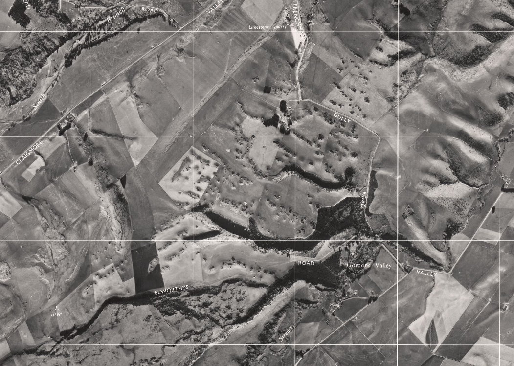
Then I saw an aerial photograph of Craigmore... The paddock looked as though it had been used for meteorite target practice. Rounded hollows covered the plateau. Some sat alone. Others formed lines and branching patterns, like a braided river after all the water had vanished.
Then I discovered that someone had numbered them. In the National Library of Australia is a map of the Craigmore doline field, accompanied by cross-sections through hollows 13, 18, 19, 28, 38, 49, 64 and 68. The collection also contains annotated copies of an aerial photograph taken on 2 May 1956.
Why was a scientist measuring holes in a South Canterbury paddock? What could their shapes tell him? And what had made them?
FYI... I am still not a geologist. I am a curious South Cantabrian trying to nut out what scientific papers, geological maps, old theses and aerial photographs can tell us. Here is what I found.
The holes have a name
Geologists call them dolines: enclosed depressions that develop in soluble rock, particularly limestone. They can be shallow bowls, steep funnels or larger, irregular hollows formed as neighbouring depressions expand and join.
Te Ara describes Craigmore as porous limestone country where rainwater filters through the rock, corrodes it and causes the surface to sink.
From ground level, grass and slope can hide the pattern, and from the air, I think they are facinating, evidence of where part of the land has slowly been dissolved and carried away in water.
The paddock began as seabed
More than 20 million years ago, there was no Craigmore plateau. This part of South Canterbury lay beneath the sea. Sand, mud, shells and fragments of marine organisms accumulated on the seabed. Burial, pressure and chemical change gradually turned those sediments into layers of rock.
In 1959, geologist H. S. Gair mapped the marine rocks of the Pareora district. He distinguished a local unit called the Craigmore Limestone from the lower Holme Station Limestone and the surrounding sandstone, mudstone and other sedimentary beds.
The modern farm stands above an ancient sea floor... that answered the fossil-shell question, but it also created another... How did seabed become a hill?
South Canterbury folded
In his 1954 University of Otago thesis, Norton Croxford described the Craigmore–Cave Hill feature as a narrow, broken anticline within the wider Pareora district.
An anticline is an upward fold in layered rock. Push the ends of a rug together and the middle buckles. Rock can deform in a broadly similar way, although under enormous pressure and over a rather less convenient timescale. As the land rose, erosion removed some softer sediments. Limestone remained within the ridge and was exposed to rain and groundwater.
Folding and faulting also created or reopened cracks. Those cracks became pathways for water.
Rain can make limestone vanish
Rain absorbs carbon dioxide from the atmosphere. As it passes through soil, it picks up more from plant roots, microbes and decaying organic matter, forming weak carbonic acid. Water slips into cracks in the rock. Small amounts of calcium carbonate dissolve and are carried away. The openings widen, allowing more water through.
Karst landscapes across New Zealand—including caves, sinkholes and underground drainage—develop through this basic process of water dissolving limestone.
Ice-age dust helped shape the surface
The limestone is only part of the story... much of lowland South Canterbury is covered by loess, fine wind-blown silt deposited during repeated cold periods. Croxford included Timaru loess among the important surface deposits of the Pareora district.
Where water enlarged cracks and openings in the limestone, soil and loess could move down into them. The surface above gradually settled into a broader hollow.
Imagine flour escaping through a cracked floorboard... the opening below may be narrow, while the depression above spreads much farther.
This is why calling the entire field a collection of collapsed caves can be misleading. Some dolines may include local collapse. Others probably formed more gradually as limestone dissolved and the softer material above subsided.
The tidy bowl visible at the surface may conceal a far messier structure underground.
The rows are clues
The dolines do not appear to be scattered randomly, Some follow lines, others form branching groups. Craigmore Station manager David Bielski described the pattern to Stuff as being like the Waimakariri River with the water removed.
That comparison may be closer to the geology than it first appears. Water follows weaknesses in rock. If fractures run in similar directions, several dolines may develop along the same zone. Some hollows may also occupy dry valleys or former drainage routes. Their positions could be influenced by the slope, the thickness of the loess, the depth of the limestone and the location of underground outlets.
The pattern may preserve two hidden maps:
- the structure of the rock;
- the routes water preferred.
- The fault is not the whole explanation
The Brothers Fault often receives a starring role in accounts of Craigmore. The wider fault-and-fold system helped raise and fracture the sedimentary rocks. Those fractures gave water places to enter.
But the fault did not directly punch hundreds of round holes into the paddock.
The full sequence is longer:
- marine sediment accumulated;
- limestone formed;
- tectonic forces folded and fractured it;
- erosion exposed it;
- water dissolved it;
- soil and loess subsided.
Faulting helped prepare the ground.
Water shaped the hollows and modern fault positions should be taken from GNS Science’s mapped fault databases rather than inferred from the pattern of sinkholes. GNS describes its New Zealand Active Faults Database as the country’s current national compilation of mapped active faults.
The man who numbered the holes
The National Library of Australia holds a folio titled New Zealand doline maps, associated with karst geomorphologist J. N. Jennings.
Its contents include:
- a map of the Craigmore doline field;
- three sheets of numbered cross-sections;
- annotated reductions of aerial photograph 2110/9;
- the original photograph, taken on 2 May 1956;
- a diagram of the major genetic types of doline.
The catalogue dates the material broadly from 1968 to 1975.
Jennings looked at a South Canterbury paddock full of holes and began giving them numbers. In April 1975, Jennings published Doline Morphometry as a Morphogenetic Tool: New Zealand Examples in the New Zealand Geographer. The paper ran from pages 6 to 28 of volume 31, issue 1.
Can measuring a hollow tell us its history?
Morphometry is the measurement of landforms. Width, depth, slope, symmetry, elongation and cross-sectional shape can all provide clues.
A long hollow might follow a fracture.
A broad, smooth bowl might reflect gradual subsidence through surface sediment.
An irregular depression may have formed as smaller dolines enlarged and joined.
A steep-sided feature could include more sudden collapse.
Jennings was using the surface to investigate a landscape hidden underground, and I suspect the holes may not share the same history, so calling every depression a sinkhole makes them sound interchangeable, where they probably are not.
The Jennings folio includes a diagram of the “major genetic types of doline”. In this context, genetic means classified by how the landform developed.
Different Craigmore hollows may record different combinations of:
limestone dissolution;
soil and loess subsidence;
local collapse;
water following fractures;
neighbouring dolines joining;
drainage concentrating in old valleys.
Some may be older than others, some may still be changing and some may contain deep sediment, while others connect more directly with openings in the limestone.
How old are they?
The limestone is more than 20 million years old. The visible dolines are younger. They could not begin forming until the rock had been raised, exposed and reached by freshwater.
There are therefore three separate clocks:
The marine sediment: More than 20 million years old.
The folded and uplifted ridge: Younger, and produced over a long period.
The present dolines: Younger again, but not yet precisely dated.
Are they still changing?
Possibly, but nobody appears to have measured the present rate.
Rain still falls. Water still moves through limestone. Fine sediment may still travel downwards.
That does not mean the plateau is about to collapse. Change could be extremely slow, and some hollows may be more active than others.
Craigmore offers an unusual opportunity to test this because the field was photographed in 1956 and measured before 1975.
Researchers could compare Jennings’s map and cross-sections with later aerial photography, modern elevation data and new field measurements.
Has doline 49 changed?
Why does number 49 appear on more than one cross-section sheet?
Have hollows joined, deepened or filled with sediment?
Jennings’s old pencil lines may allow future researchers to measure what water has done over half a century.
The hollows may contain another archive
Dolines collect material.
Dust, pollen, charcoal, seeds, leaves and soil can accumulate in their bases.
A sediment core might preserve evidence of changing vegetation, fire, erosion, climate and farming.
I have not found a published Craigmore study showing that this has been done.
For now, it remains a research possibility.
The hollows may preserve two histories at once: limestone disappearing below and the environment changing above.
Why do tī kōuka grow in some of them?
Photographs show tī kōuka growing in and around several dolines.
The hollows might provide shelter, deeper soil, extra moisture or places less accessible to stock and machinery. They could also collect cold air and experience heavier frost.
Without a Craigmore-specific ecological study, anything further would be guesswork.
It is another example of the landscape refusing to answer one question without generating three more.
The aerial view and the farming view
From above, the dolines are beautiful, but I can imagine on the ground they are pretty dangerous. A geologist might see an exceptional karst field, but a farmer sees ground that must be negotiated every day.
The limestone also made shelters
The wider Pareora limestone country contains caves, overhangs and culturally significant Māori rock-art shelters.
The geological connection is clear: water and erosion shaped the same broad limestone landscape into different forms.
Geology can explain how a shelter formed. It cannot explain what that place means, who holds authority to speak about it or how it should be visited. Te Ara notes that generations of Māori created art on the walls of caves and natural shelters, including a well-known pouākai design associated with Pareora. Detailed interpretation should come from mana whenua and the organisations entrusted with caring for these places.
Craigmore is private land
The doline field lies on a working farm. It is not a place where you can turn up unofficially for sightseeing. Please do not wander onto the plateau looking for doline 49.
I began the previous blog by asking whether dinosaurs had walked through Timaru... I did not find a local dinosaur. I found a succession of lost landscapes: a sea older than dinosaurs at Kākahu; marine reptiles in Canterbury waters; later oceans containing shells, turtles and whales; lava travelling towards an earlier Timaru coast; and ice-age dust settling over the land.
Craigmore adds another.
An ocean floor became limestone. The limestone rose into a ridge. Wind covered it with dust. Water began removing it from below. Humans arrived near the end and found a paddock full of holes.
Timeline
What ordinary things can do with enough time
Look again at the aerial photograph... it seems to show the aftermath of one violent event. Craigmore developed through small processes repeated for an almost unreasonable length of time.
A shell fell to the seabed.
Sediment covered it.
Rock folded.
Rain entered a crack.
A grain of loess slipped downwards.
Then another.
The hollows are not meteorite scars.
They are evidence of what water, gravity and time can accomplish without making much noise.
And somewhere in an Australian library, a map still holds their numbers.
Craigmore Timeline
Deep-time dates are approximate. Modern place names are used only to help locate the story.
More than 20 million years ago
Marine sediment accumulated
Sand, mud, shells and fragments of marine life collected on the seabed. Some of this material later became the Craigmore Limestone.
Evidence: H. S. Gair’s geological account of the Pareora district.
Later
Sediment became rock. Burial, pressure and chemical reactions transformed loose marine sediment into limestone, sandstone and mudstone.
Later again
The rocks folded and fractured
Tectonic deformation raised the Craigmore–Cave Hill structure and produced cracks through which water could later move.
Evidence: Croxford’s 1954 thesis and later regional geological research.
During repeated cold periods
Wind deposited loess
Fine, wind-blown silt accumulated across lowland South Canterbury.
After the limestone was exposed
Karst development began
Weakly acidic water entered cracks, dissolved limestone and carried calcium carbonate away.
Over time
The surface subsided. Soil and loess moved into developing openings, helping create the smooth depressions visible today.
1954
Norton Croxford completed Geology of the Pareora District. His University of Otago MSc thesis described the district’s landforms, sedimentary rocks, basalt and Timaru loess.
2 May 1956
The doline field was photographed. Crown aerial photograph 2110/9 recorded the Craigmore landscape.
Approximately 1968–1975
J. N. Jennings mapped and measured the dolines. His research folio included the field map, annotated aerial images, numbered cross-sections and a diagram comparing doline types.
April 1975
Jennings published his morphometry paper. Doline Morphometry as a Morphogenetic Tool: New Zealand Examples appeared in the New Zealand Geographer.
4 February 2022
The field reached a wider public audience
Stuff published Chris Hyde’s account of the dolines, including observations from Craigmore Station manager David Bielski and GNS geologist David Barrell.
Today The landscape still holds unanswered questions. The exact number, age, underground connections and present rate of change of the dolines remain uncertain.
Sources and Further Reading
Craigmore dolines and J. N. Jennings National Library of Australia
New Zealand doline maps [cartographic material] Catalogue record for the folio containing the Craigmore doline-field map, numbered cross-sections, the doline-type diagram and aerial photograph 2110/9. https://catalogue.nla.gov.au/catalog/4223024
Jennings, J. N. “Doline Morphometry as a Morphogenetic Tool: New Zealand Examples.” New Zealand Geographer, volume 31, issue 1, April 1975, pages 6–28.
https://doi.org/10.1111/j.1745-7939.1975.tb00793.x
Crossref record: https://api.crossref.org/works/10.1111/j.1745-7939.1975.tb00793.x
National Library of Australia Joe Jennings map collection Background on Jennings and the international scope of his research. https://catalogue.nla.gov.au/catalog/4200840
National Library of Australia Material gathered for karst books and ANH 1975 Related Jennings research material concerning karst, caves, fissures, springs and underground drainage. https://catalogue.nla.gov.au/catalog/4219524
Pareora and Craigmore geology Croxford, Norton James William Geology of the Pareora District. MSc thesis, University of Otago, 1954. https://theses.otagogeology.org.nz/items/show/3
Gair, H. S. “The Tertiary Geology of the Pareora District, South Canterbury.” New Zealand Journal of Geology and Geophysics, volume 2, 1959, pages 265–296.
https://doi.org/10.1080/00288306.1959.10417648
Langdale, S., and Stern, T. A. “Late Tertiary Deformation in Cannington Basin, South Canterbury, New Zealand: Evidence from Seismic and Gravity Data.” New Zealand Journal of Geology and Geophysics, volume 41, 1998, pages 247–257.
https://doi.org/10.1080/00288306.1998.9514808
Public explanations
Te Ara – The Encyclopedia of New Zealand
Craigmore’s sinkholes https://teara.govt.nz/en/photograph/11298/craigmores-sinkholes
Te Ara – The Encyclopedia of New Zealand
Limestone country https://teara.govt.nz/en/limestone-country
Stuff “The Craigmore sinkholes: How a field that looks like it was hit by meteorites was created in South Canterbury.” Chris Hyde, 4 February 2022.
Geological maps and faults
GNS Science Geological Map of New Zealand https://www.gns.cri.nz/data-and-resources/geological-map-of-new-zealand/
GNS Science GNS Web Maps https://maps.gns.cri.nz/
GNS Science New Zealand Active Faults Database https://www.gns.cri.nz/data-and-resources/new-zealand-active-faults-database/
GNS Science New Zealand Active Faults Map https://www.gns.cri.nz/data-and-resources/new-zealand-active-faults-map/
Historic aerial imagery Toitū Te Whenua Land Information New Zealand
Historical aerial imagery https://www.linz.govt.nz/products-services/data/types-linz-data/aerial-imagery/historical-aerial-imagery
Retrolens Historic Crown aerial photography https://retrolens.co.nz/
Māori rock art and limestone shelters Te Ara – The Encyclopedia of New Zealand
Māori rock art – ngā toi ana https://teara.govt.nz/en/maori-rock-art-nga-toi-ana
Te Ara – The Encyclopedia of New Zealand Rock-art designs https://teara.govt.nz/en/maori-rock-art-nga-toi-ana/page-2
Te Ana Māori Rock Art Centre https://teana.co.nz/
Acknowledgements
This article draws on scientific papers, university theses, geological maps, historic aerial photography and library collections made available by the University of Otago, GNS Science, Toitū Te Whenua Land Information New Zealand, Te Ara and the National Library of Australia.
Special thanks are due to the researchers, librarians, farmers and local observers whose work has helped make the Craigmore landscape legible.
This is a general reader’s attempt to understand and communicate published research. It does not replace specialist geological, archaeological or cultural advice.
The Craigmore doline field is on private working farmland. Please do not enter without permission.
Corrections, historic photographs and further information about the landscape are warmly welcomed.