
By Roselyn Fauth

How many times have you walked down Stafford Street without really looking at it?
The funny intersection at North Street. The bluestone kerbs. Names above old buildings. A street that slopes towards the sea. None of those things are accidental. They are clues.
If you know how to read them, an ordinary walk through Timaru can take you back to Māori travel routes and mahika kai, two competing town plans, beach landings, a devastating fire, railways, harbour building, politicians, shopkeepers and the workers who actually built the town.
You don't need to be a historian to start... You just need to notice something and ask: Why is that there?
Next time you walk down Stafford Street, look a little closer... Look up and down at the buildings, kerbs, street names, old stone, the slope towards the sea and those intersections around North Street that don't quite line up. They are clues to how Timaru developed.
A lot of my WuHoo history hunts start this way, I notice something ordinary that catches my attention. I wonder why it is there, then start following maps, photographs, newspapers and whatever other records I can find.
Sometimes I get an answer. Sometimes I get three different answers. Occasionally I end up with another mystery... and side quests.
That is probably the most useful thing I can share with anyone researching a Timaru street or building. Look first. Ask questions. Then check what the evidence actually says.
For me, it comes down to three things:
- Notice. Question. Check.
- And one question that is worth asking all the way through:
- How do we know?
Before there was a Stafford Street
As we know, Timaru's story did not begin when European surveyors drew streets across a map.
Kāti Huirapa hold mana whenua in the Timaru district and are represented by Te Rūnanga o Arowhenua. Timaru was part of an extensive Ngāi Tahu network of kāika, mahika kai, travel routes and places connected with gathering food and other resources. Heritage New Zealand records a description from Hoani Kahu of Arowhenua identifying Timaru as an old settlement, permanent dwelling place, sacred place, burial place and waka landing place.
This is an important starting point, because maps can be powerful... but they can also be misleading if we assume that everything not drawn on them did not exist.
Ngāi Tahu's Kā Huru Manu cultural mapping project records traditional place names, travel routes and histories using information from whānau manuscripts, nineteenth century maps, books, newspapers and other records. More than 1,000 traditional names have been mapped.
Put Kā Huru Manu beside an early European survey of Timaru and ask: Are these maps telling us the same story?
They are both maps, but they were created for different purposes and record different knowledge. I have learned on my history hunting that this is something worth remembering whenever we use a historical source.

In 1839 the Sydney-based Weller brothers established a short-lived whaling station at Timaru. By the time Walter Mantell made this sketch, in 1848, the station was deserted. Mantell, Walter Baldock Durrant, 1820-1895 :MotuMotu, Timaru. Oct 20 Friday 1848.. Mantell, Walter Baldock Durrant 1820-1895 :[Sketchbook, no. 2] 1848. Ref: E-333-006. Alexander Turnbull Library, Wellington, New Zealand. /records/22810746
How did the colonial town appear?
Before getting to Rhodes Town and Government Town, there is another part of the story... Much of Canterbury, including South Canterbury, came within the 1848 Canterbury Purchase, usually known as Kemp's Deed.
The transaction became one of the major Ngāi Tahu grievances. Promises were made about reserves, schools, hospitals and continued access to mahika kai, while the area retained for Ngāi Tahu was tiny compared with the land transferred to the Crown. That history has a direct connection with Timaru.
A 20-acre Māori reserve was established near Caroline Bay. It later became known as Reserve 884. Part of it was taken for the railway in the nineteenth century, and the remainder was eventually purchased by Timaru Borough Council. So the history of land, the beach landing places, railway development and the growth of the colonial town overlap.
Kāti Huirapa did not disappear from the story when Timaru was surveyed. They remain mana whenua today.
Two towns that did not quite line up
One of my favourite clues is still visible around North Street, although it is being slowy erased as we realign streets and insert round-a-bouts.
You too might notice that some of the intersections done line up. Well that's because early European Timaru developed from two separately surveyed settlements.
The Rhodes brothers acquired land north of the later government settlement in 1853, and their private township became known as Rhodes Town.
In 1856, Canterbury Provincial Government surveyor Samuel Hewlings laid out Government Town further south.
Government Town was expected to become the centre, but Rhodes Town had a practical advantage. It was closer to the beach landing places.
People and cargo came ashore there. Shops, accommodation, merchants and other businesses followed. I think the Rhodes brothers were clever they managed to get the churches and the banks in their town. And while the government had the civic buildings, like the gaol, police station, court, and hospital, the civic center was at the harbour, where people needed to be logistically close to the exchange of people and things between the region and the world.
Eventually the two street systems had to meet, and they did not fit together perfectly, which helps explain some of those odd intersections around North Street today.
It is a nice example of history being visible in the shape of the town, and interestingly we dont have a information sign or a plaque that explains this.
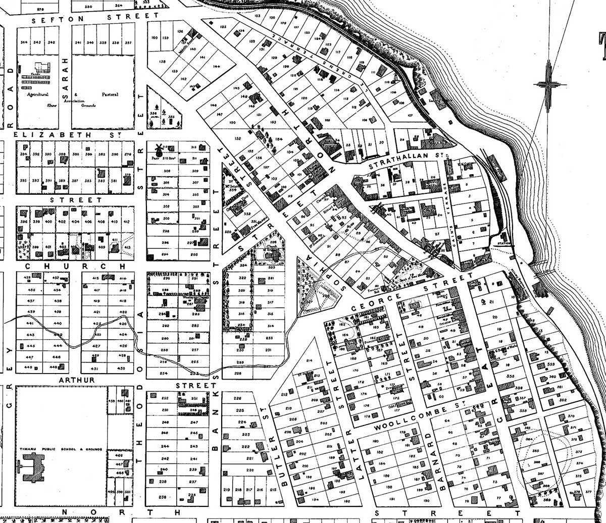
Plan of Timaru Townships, Canterbury, N.Z., 1875. Scale 3 chains to an inch. Lithographed at the Lyttelton Times Office, Christchurch, N.Z. - Courtesy of the Timaru District Council

1860 Timaru town. NZ Heritage Maps Platform, https://maps.recollect.co.nz/nodes/view/1138
Why Stafford Street grew where it did
Early Timaru did not have the port that we see today, where ships could pull up alongside a warf. Before the 1870s, ships anchored offshore and passengers and cargo were transferred through the surf. The beach landing services were an essential part of the early settlement.
Goods came in. South Canterbury produce went out. Businesses naturally clustered around the routes connecting farms, landing places and the growing town.
Later, the railway and harbour strengthened those connections. The railway between Timaru and Temuka opened in 1875, followed by connections north and south. The Timaru Harbour Board was established in 1877 and work on the breakwater began the following year.
Once you start thinking about transport, a lot of central Timaru makes more sense.
- Warehouses near the railway.
- Hotels near busy transport routes.
- Banks serving merchants and farmers.
- Government offices near the port.
A building's location can tell you as much as its construction date.
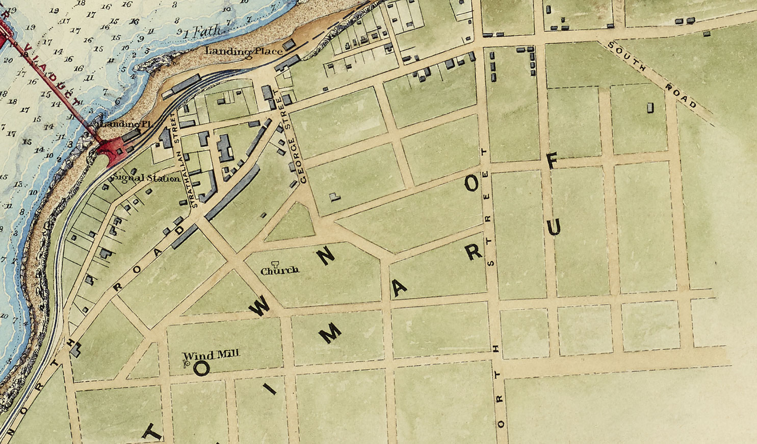
Both Great North and Great South Roads appear on this 1875 map. Timaru Foreshore. NZ Heritage Maps Platform, accessed 17/05/2026, https://maps.recollect.co.nz/nodes/view/404
The fire of 1868
Now imagine standing outside the Old Bank on Church St and Stafford Street corner. and look towards Hallenstiens. On 7 December 1868 this was a furniture store, and behind was a workshop. a 10 year boy was helping out the back melting some glue over a fire, the shavings on the floor caught fire and they couldn't get it under control. That afternoon ablustery hot nor west wind was blowing fire, and with no water, and a wooden town, there was little people could do but run to safetly. In just three hours the fire tore from this corner up to Woollcombe Street, destroying three-quarters of the buildings central Timaru. Many only got out with the clothes on their backs and were under insured.

The fire started behind the shop on the far right. Looking across Strathallan Street from site of P.G.G.. Hocken Snapshop. hocken.recollect.co.nz/24022

The Ship Hotel on the corner of Strathallan and Stafford Street, Timaru, sometime in the 1860s prior to the fire of 1868. A copy negative, believed to have been taken by William Ferrier, of an original print. South Canterbury Museum - CN: 2019/049.34
The council introduced a new bi-law in the central business area that new builds had to be in brick and stone. That decision is still visible.
The bluestone, brick and plaster buildings along Stafford Street are not simply there because Victorians and Edwardians liked the look of them. The disastrous fire helped change the materials used to rebuild the town.
This is one of the things I enjoy about built history. A building can be evidence of an event that happened long before anyone alive today was born. They are like signposts to help us travel back in time with our imaginations and work out what life has been like here for people in the past.
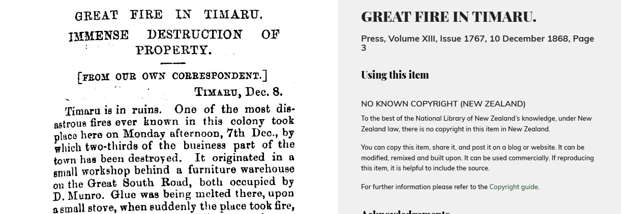
An article about the great fire of Timaru published 1868 referrs to Great South Road. GREAT FIRE IN TIMARU. Press, Volume XIII, Issue 1767, 10 December 1868, Page 3 https://paperspast.natlib.govt.nz/newspapers/CHP18681210.2.17

Postcard - Timaru April 1876 Herald Office on Great South Rd and other buildings. (Stafford street just down from Theatre Royal). The obscured building on left is the Criterion Hotel, later renamed the Excelsior. - Curtosy of Jason Westaway

George Street, Timaru. Hocken Digital Collections, accessed 17/04/2025, https://hocken.recollect.co.nz/nodes/view/23495

The treasury can be seen on the left beside the Club Hotel. Rejoicing at Timaru - Surrender of Austria by William Ferrier. Hocken Snapshop. hocken.recollect.co.nz/24087
The town under your feet
Some of Timaru's older kerbs are made from local bluestone, a basalt formed through ancient volcanic activity.
It was quarried and used throughout the town for buildings and public works.
By the 1880s the Borough Council was debating street improvements, including footpaths, drainage and kerbing. Some roads were still being described as being ploughed and harrowed.
That gives quite a different picture from the tidy old photographs we often see... Timaru was muddy. Drainage was a problem. Streets needed maintaining. Money had to be found and people had to do the work.
Someone quarried that bluestone, cut it, carted it and then laid it. Of course these are civic engineering details that we use every day, and I bet many of us don't even notice. That's because it was done well. We would definatly notice if the engineering and construction hadn't been done well.
Once I started thinking about that, kerbs became much more interesting.

An unused postcard entitled "Timaru Drainage Works. Changing Shifts", circa 1910. Depicts Council Workers on King George Place, posed behind a pair of bicycles leaning against the barricade beside the work site. Handwritten on verso "Probably 1910/12" - presumably during the term of Mayor James Craigie who initiated a programme of underground drainage (to replace the previous open drain). South Canterbury Museum 4616

1909 Photograph taken by an unidentified photographer employed or contracted by 'The Press' newspaper of Christchurch.Stafford Street, Timaru, with carts, horses and people in the street. The Press (Newspaper) :Negatives. Ref: 1/1-008815-G. Alexander Turnbull Library, Wellington, New Zealand. /records/29944621
The people who made the buildings
When we talk about historic buildings, we tend to remember the owner or architect, I also like looking for the other people.
The former Timaru and Gladstone Board of Works Building at 95 Stafford Street was built in 1874. Thomas Roberts designed it and Thomas Machin was the contractor. Machin had come to Canterbury as a bricklayer.
That small detail tells us something useful. Timaru's built heritage is also the history of trades and labour.
Bricklayers, stonemasons, carpenters, ironworkers, painters and labourers physically made the town we inherited.
Their names are not always the ones written across the façades.
Stafford who?
Stafford Street was not always Stafford Street. For many years it was known as Great North Road. In September 1889 it was renamed after Edward William Stafford, who had represented Timaru in Parliament and served three times as Premier of New Zealand.
Finding out who Stafford was is fairly straightforward... The more interesting part is thinking about why his name was chosen.
Street names tell us something about the people a community wanted to remember at a particular time. They also tell us something about who had the authority to do the naming.
It is worth asking whether we would make the same choices today, but we also need to understand the values and politics of 1889 before judging the decision.

c.1910. Originally a Temperance Hotel, it was built close to the Railway station on the corner of George and Cains Terrace. The front right hand side of the postcard reads: 'This popular Private Hotel is close to the Railway Station and affords excellent accommodation for travellers and tourists. Tariff moderate. Letters and telegrams promptly attended to. Werry's Private Hotel, Timaru. (M. Werry, Proprietress)'. Muir & Moodie (Firm), Werry's Hotel, Timaru, N.Z. (c.1910). Hocken Digital Collections, accessed 17/04/2025, https://hocken.recollect.co.nz/nodes/view/52777. No known copyright or other restrictions on use exist in this image. Permission to use this item for any purpose, including publishing, is not required from the Hocken under these conditions of use.

Crowds gather to watch the parade, led by a horse-drawn carriage on a street lined with commercial buildings, Timaru, to celebrate the coronation of George V. The Press (Newspaper) :Negatives. Ref: 1/1-008620-G. Alexander Turnbull Library, Wellington, New Zealand. /records/29942057
The Customhouse
Timaru's former Customhouse is another building that makes more sense once you look at where it stands. Designed by Daniel West, it opened in 1902 close to the harbour and railway. There was an earlier building but it was demolished to make way for the railway line.
Customs work was tied to shipping, imports, exports, merchants, so the location was practical. As well as controlling the sea boarder, the taxes were critical government revenue, and helped fund the roads, bridges and rail that we still used today.
This building's architecture was nwo-classical design, with its symmetry, columns and formal entrance. This Government buildings design was deliberate, and gave the building a sense of authority.
But one of my favourite details is much smaller.
Look closely at the ironwork and you can find the name of Timaru firm J. Storrier and Co. A maker's mark can shift our attention from the grand building to the local people who helped create it.
It is a good reminder not to stop with the architect. Who supplied the materials? Who made the ironwork? Who worked inside the building? Who maintained it?
Those stories count too.
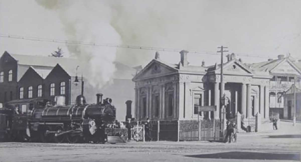
Railway locomotive next to the Customhouse at Timaru p13 1910-1920 South Canterbury Museum 3873

An unused Muir and Moodie postcard entitled "The Railway Station and Wool Stores, Timaru N.Z.", 1907. Depicts the a view looking south along the railway tracks toward a north bound train at the station. In the foreground at the right is the original car and wagon depot, while the Evans and Co. (Atlas) Flour Mill can be seen beyond the railway station. South Canterbury Museum 2685
Two maps can tell different stories
If I was researching this area for a school project, I would put an early colonial survey beside Kā Huru Manu.
The colonial map might record streets, property boundaries and European names.
Kā Huru Manu records Ngāi Tahu names, routes, reserves and histories associated with the whenua.
The useful part is not deciding which is the “right” map.
Ask why each one was created and what knowledge each preserves.
That is a much better way to use historical sources than simply copying information from them.
When the answer is not there
Research does not always end neatly... one of my favourite rabbit holes involved early Timaru brickmaker Nathan Fisher.
An 1872 advertisement said he had 27,000 bricks ready for delivery. I wanted to know where they went. I found Fisher. I found his business. I found evidence that he was producing and selling bricks. What I did not find was proof that a particular surviving Timaru building was made from them. So that remains unresolved.
I find it useful to separate research into three categories:
- What we know.
- What seems likely.
- What still needs checking.
They are not the same thing... if ten websites repeat a story, they may all have copied one source.
If somebody has written a date beneath an old photograph, it is still worth asking where the date came from.
And if two good sources disagree, that is not necessarily a problem. It may be the start of a better question.
I have found sometime the history that was recorded was written with an agenda, perhaps as an obituary retold by friends, or propoganda to support an important mission, to build a harbour for the region to prosper. Sometimes I need to think critically about the source that I am usuing to make sure I am careful with how I interpret it and share it. That is also why including citaions is important, so others can follow your journey. Acknowleding sources also shares the mana of the history hunt, and gives credit to others who have spent time researching too.
Reading your own street
If you are researching a Timaru street or historic building, start with the place itself.
Look at the materials, street layout, alterations, signs, names and surrounding landscape.
- Think about why it is there.
- What was there before?
- Who owned, designed or built it?
- Who used it?
- What changed around it?
Then look for evidence.
Historic photographs, maps, newspapers, directories, council records, museum collections, heritage reports, oral histories and mana whenua sources can all add something different.
You will probably find some people much more easily than others... That is another clue. The historical record does not preserve everybody equally.
History hiding in plain sight
An awkward intersection can lead to two competing town plans.
A map can take us into colonisation and land ownership.
A small reserve near Caroline Bay can connect mana whenua, beach landing places and railway development.
A street name can lead to politics.
Bluestone can lead to geology, council decisions and workers.
A brick building can take us back to the fire of 1868.
The harbour and railway help explain why businesses developed where they did.
A tiny maker's mark can put a worker back into the story.
And 27,000 bricks can leave us with a question we still cannot answer.
That is local history...
The dates help us put things in order, but I am usually more interested in why something happened and what traces it left behind.
So next time you walk through Timaru, look at something you normally pass without thinking about.
See what you notice... then ask why it is there? You might be surprised where the question takes you. You might find the answers straight away, or you might find a story that has been missing or sitting in the margins ready to be pulled out onto the page.
Why does knowing this stuff matter?
You don't need to know the history of every building or remember every date to belong somewhere. But knowing something about the place where you live can change the way you see it.
A street stops being just a route from one place to another. An old building becomes part of a bigger story. A name on a map might make you wonder who chose it, what was there before and whose story has been remembered.
That builds a sense of place. It helps us understand that Timaru didn't simply appear as the town we know today. It was shaped over generations by mana whenua, settlers, workers, businesses, local government, transport, disasters, new technology and thousands of everyday decisions.
Knowing that history can also help us understand why things are where they are. Why the town centre developed near the sea. Why some streets don't quite line up. Why bluestone appears in our buildings and kerbs. Why the railway, harbour and Stafford Street became so important.
It also makes us better at noticing change. Some things that once seemed permanent have disappeared. Others have survived because people valued, adapted or reused them. If we know what a place has meant to people in the past, we are in a better position to think about what should happen to it in the future.
Local history can give us a stronger connection to the people who came before us, but it should also make us curious about the stories that are harder to see. Who did the work? Who made the decisions? Whose names were recorded? Whose weren't? What did this place mean before the buildings and streets we recognise today were here?
For me, that is one of the best reasons to explore local history... It helps us know where we are.
Not just geographically, but in the much longer story of this place. And once you know a little of that story, it becomes much harder to walk through Timaru without noticing it.
Local materials used

Bluestone: The blue stone basalt rock formed by lava is not found anywhere else in New Zealand. It is unaffected by weather, low in maintenance, non slip and will last for generations. Architects, were aware of this versatile stone early on, a lasting heritage established for generations to come. Late 1800s through early 1900s multiple quarries in Timaru with the most notable being those in the Scenic Reserve or Centennial Park. Rail lines that carried rock to port from this area finally decommissioned fully by 1959. By 1935 moves to create the Scenic Reserve, shortly renamed Centennial park, began. From 1988 group formed to create the park reserve, lake, bridges and planting we know today. stuff/Scenic-park-full-of-beauty-and-history

Oamaru Stone: Limestone granular and creamy white. The crushed stone can be used as a soil conditioner. The sedimentary rock Tiny algae living in the water (called diatoms) became preserved in sediment (called diatomite) as fossils Thirty-five million years ago, the Oamaru area was under the sea.
Palliser Block: Hollow concrete blocks made using a distinctive mould often used in foundations. Mr Frank Palliser was a Timaru builder. He imported a Palmer’s machine in 1906 to form pre-cast concrete blocks. The Timaru Borough Council modified their building bylaw to permit the use of hollow concrete block and Mr Palliser had presented a drinking fountain for Caroline Bay (perhaps as a bit of a marketing stint). Just 6 years later, in 1912, Timaru was promoting itself as exporting ‘sunny-tempered people and hollow concrete building blocks, but retains large numbers of both for its own use’. Learn more here
Bricks: There were many brickmakers in South Canterbury. Harpn Exley )1832-1888 is recorded as Timaru's first brickmaker, preparing bricks for chimneys as early as 1859. In 1866 he was contracted to dig a well behind Bank of New Zealand at 4 shillings per foot. He arrived with his wife Susan Ellis and two year old son Albert on the Strathallan.
Elements to look for on your way

 Acroterion
Decorative pedestal for an ornament or statue placed atop the pediment.
 Cartouche
Originally used by the Egyiptians as an emblem or seal, they were also decorative element, framed oval surrounded with scrolls over an entrance, this is known as a Cartouche in Architecture. The word 'cartouche' comes from the French language, where it means something similar to a scroll of paper.
 Quoins
A quoin is an angle at the outside corner of a building. These cornerstones are both decorative and structural.
Cornice
The decorated projection at the top of a wall provided to protect the wall face or to ornament and finish the eaves.
The term is used as well for any projecting element that crowns an architectural feature, such as a doorway.
 Dentilled Cornice
Small block used as a repeating ornament in the bedmould of a cornice. Dentils are found in ancient Greek and Roman architecture
 Columns
There are five orders of ancient architecture: Tuscan, Doric, Ionic, Composite and Corinthian. See Nicholson’s ‘New Practical Builder’, c1824
 Pediment
Triangular gable forming the end of the roof slope over a portico (the area, with a roof supported by columns, leading to the entrance of a building); or a similar form used decoratively over a doorway or window.
Frieze
Is above the architrave and below the cornice (in a position that could be quite difficult to view). The term also refers to any long, narrow, horizontal panel or band used for decorative purposes like on the exterior walls of buildings.
Capital
Crowning member of a column, pier, anta, pilaster, or other columnar form, providing a structural support for the horizontal member (entablature) or arch above. In the Classical styles, the capital is the architectural member that most readily distinguishes the order.
Parapet
A dwarf wall or heavy railing around the edge of a roof, balcony, terrace, or stairway designed either to prevent those behind it from falling over or to shelter them from attack from the outside
Orial Window
A bay window which protrudes from the main wall of a building but does not reach to the ground.
Final
Decorative element to emphasise the aped of a dome, spire, tower, roof or gable.

Rustication
Is a type of masonry treatment where block making a wall have exaggerated joints.
Spy principal columns
When you look around the Timaru CBD you will see lots of columns! As well as serving as a support, they can be beautifully decorated to add to the athestics of a building. The invention of the column allowed for the support of ceilings without the use of solid walls. Columns increase the space spanned by a ceiling, allowing the entrance of light and offering an alternative aesthetic to building exteriorsYou will see some incorporated (engaged) within walls or be free-standing and carry sculpture.
The first use of columns was as a single central support for the roof of relatively small buildings but from the Bronze Age (3000-1000 BCE) more sophisticated columns with other functions beyond direct structural support appeared in the Egyptian, Assyrian and Minoan civilizations. The First Stone Columns can be seen in Greece when stone began to replace wood. Some were carved in one piece, as buildings became bigger, columns began to be constructed from separate drums. The evolution of columns in the ancient world has been classified within architectural orders. The three principal orders are Doric, Ionic, and Corinthian.
Doric columns were wider at the bottom and had a simple capital but no base
Ionic columns stand on a base and have a capital in the form of a double scroll (volute).
Corinthian columns are usually slimmer and taller, stand on a base and have a richly decorated capital, usually with sculpted flower and leaf decoration.
These three all have vertical fluted carving. The Romans introduced the Tuscan column which had no flutes and a simple base and capital. Roman Doric columns were similar but with flutes. Composite columns appeared which mixed elements of the previous styles and finally, there were Solomonic columns with a twisted shaft.

The above image was created in 1892 by Leipzig und Wien.
Below are examples of columns that you can find in the Timaru Central Business District.


Original wooden Grosvenor that got burnt down in fire. Circa 1875 - Picture of Grosvenor Hotel, Timaru

1916 Exterior view of the Grosvenor Hotel, Timaru, circa 1916, photographed by Frederick George Radcliffe. Timaru. F.G.R. 5553 - National Library 1/2-006876-G & hocken.recollect.co.nz/52786 No known copyright or other restrictions on use exist in this image.

Map Timaru CBD


1900 Street scene, Stafford Street, Timaru, including horses and carts. The Press (Newspaper) :Negatives. Ref: 1/1-008712-G. Alexander Turnbull Library, Wellington, New Zealand. /records/29945985

1914 Departure of the 2nd (South Canterbury) regiment from Timaru, during World War I. Young, J (Mrs) :Photographs of Otago, South Canterbury and Wellington. Ref: 1/2-049274-F. Alexander Turnbull Library, Wellington, New Zealand. /records/23136046

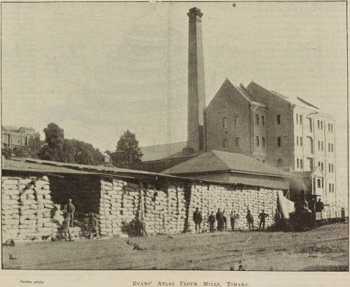
A mounted photograph entitled "Evans' Atlas Roller Flour Milling Company, Timaru, N.Z", circa 1892. Shows the grain storage area to the south of the mill (in the background) prior to the second grain store being built in 1897. The grain is shown stored in a long open fronted shed which is almost full with sacks of grain. Several men are standing in front of the shed and to the right is the Evans' Atlas building. In front of the building is the locomotive 'A' 68 linked to wagons also loaded with grain. South Canterbury Museum 2775
https://kura.aucklandlibraries.govt.nz/digital/collection/photos/id/116832/


Timaru Flour Mills 1972_Tiaki Ref Num WA-70626-F-PA-Group-00080 Whites Aviation Ltd Photographs


1911 A fleet of motor cars in parade, on a street lined with commercial buildings, Timaru, to celebrate the coronation of George V. The Press (Newspaper) :Negatives. Ref: 1/1-008618-G. Alexander Turnbull Library, Wellington, New Zealand. /records/29944218

1900 Stafford Street, Timaru. Webb, Steffano, 1880-1967: Collection of negatives. Ref: 1/2-031169-G. Alexander Turnbull Library, Wellington, New Zealand. /records/22734187
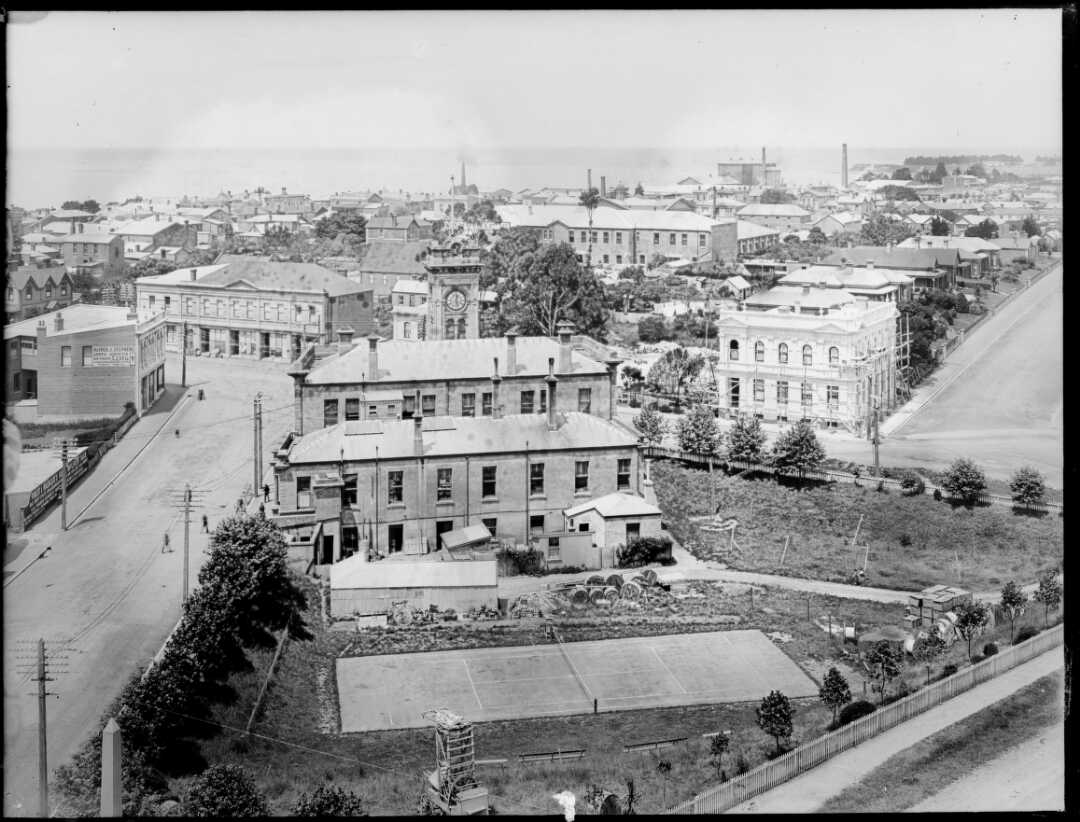
1900. Alexander Turnbull Library, Wellington, New Zealand. /records/692723

St Mary's Church, Timaru, New Zealand, 1912, Timaru, by Muir & Moodie studio. Purchased 1998 with New Zealand Lottery Grants Board funds. Te Papa (PS.002215)

1900 Timaru township and harbour. The Press (Newspaper) :Negatives. Ref: 1/1-008710-G. Alexander Turnbull Library, Wellington, New Zealand. /records/29947970
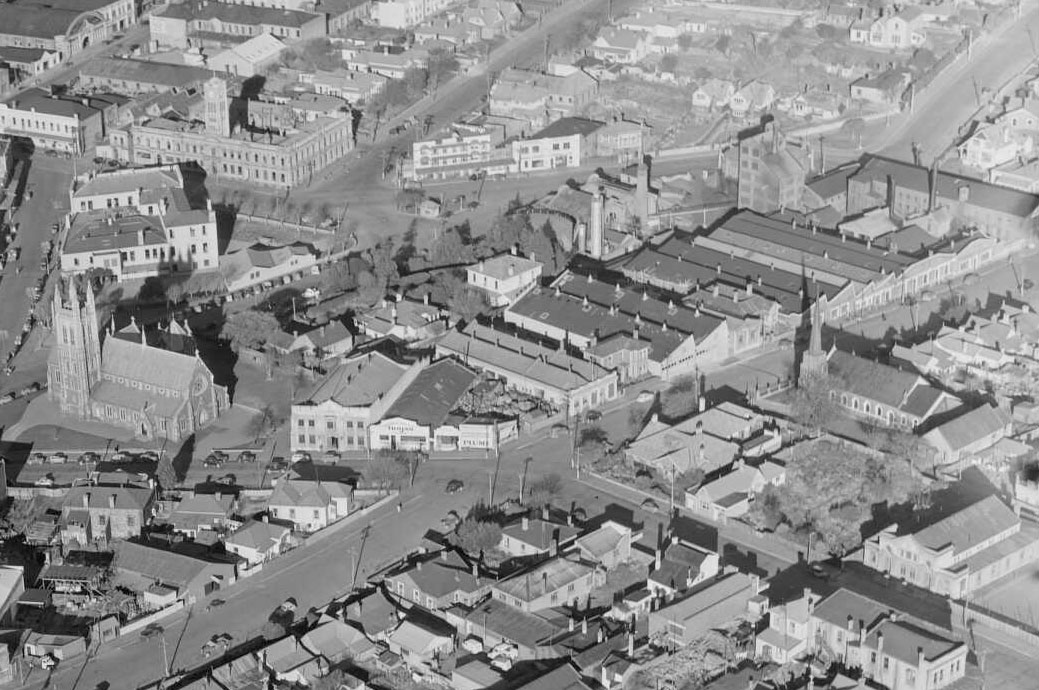
1951 Bank St Church Timaru - Crop from photo. Alexander Turnbull National Library 669600

Scene in Timaru, with Chalmers Presbyterian Church on right. A woman with a perambulator can be seen walking along the road in the foreground. Photograph taken after 1903 by a staff photographer for The Press newspaper: (PA-Group-00103: The Press (Newspaper) :Negatives 523290)

1915 Looking down Stafford Street in Timaru, circa 1915, with shops lining both sides of the street. The shop second in from the right, with the ornate facade, is the business of T & J Thomson. Cars, horse drawn carriages and bicycles can also be seen on the street. Taken by Frederick George Radcliffe. Tiaki IRN: 133640 Tiaki Reference Number: 1/2-006892-G Collection: PA-Group-00408: Radcliffe, Frederick George, 1863-1923 : New Zealand post card negatives
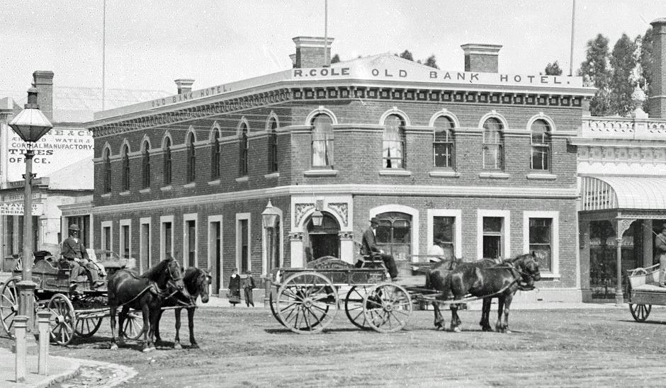
From the Old Bank Facebook Page

Overlooking Church Street and towards the harbour, Timaru. You can see the Old Bank on the Corner of Stafford and Church Street. - The Press (Newspaper) :Negatives. Ref: 1/1-008810-G. Alexander Turnbull Library, Wellington, New Zealand. /records/29946828

Corner of Stafford, Church and Strathallan Streets. Store SC Dresden - sold pianos. The Old Bank Hotel Robert Bowie, Stafford St., sold pickles.

1910 New Zealand Government Life and Accident Insurance building, Stafford Street, Timaru, with men, horses and carts in the foreground. The Press (Newspaper) :Negatives. Ref: 1/1-008809-G. Alexander Turnbull Library, Wellington, New Zealand. /records/29939829

Stafford St. 1941. Photographer New Zealand Herald W B Beattie. 'Sir George Grey Special Collections, Auckland Libraries, 1370-464-02' when re-using this image. Hay's Building to the right. Learn more

Premises of Cecil Pattillo, photographer, in Stafford Street, Timaru. Hocken Snapshop. hocken.recollect.co.nz/24042

1900 Stafford Street, Timaru, with people standing in the street, horses and carts and people on bicycles. The Press (Newspaper) :Negatives. Ref: 1/1-008716-G. Alexander Turnbull Library, Wellington, New Zealand. /records/29947735

Timaru, 1902, Timaru, by Melvin Vaniman. Purchased 2024. Te Papa (O.051719)

Section of photo Timaru, 1902, Timaru, by Melvin Vaniman. Purchased 2024. Te Papa (O.051719)
https://collections.tepapa.govt.nz/object/2314850?page=1&rtp=1&ros=1&asr=1&assoc=all&mb=c