
by Roselyn Fauth
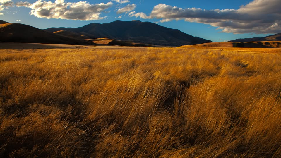
We've been taking this drive for years. It's one of our favourite ways to spend a Sunday, especially when family comes to visit from overseas... we pack a picnic, head into the South Canterbury countryside and show them a part of New Zealand they might never discover on the usual tourist trail.
It's not a road to race along. There are shingle roads, farm gates and plenty of excuses to stop for photographs. You need to allow time, and that's half the enjoyment. On a clear day, the views across the Mackenzie Basin towards Aoraki/Mount Cook are spectacular. Golden tussocks, immense valleys and the Southern Alps stretching across the horizon. So I was stoked to stumble across an article from 1938 encouraging people to discover this very landscape.
Nearly 90 years ago, somebody else thought it was worth making the journey!
A new tourist road in 1938
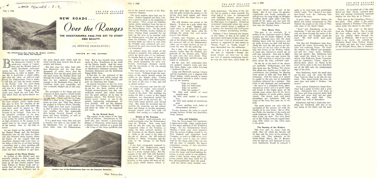
On 1 July 1938, The New Zealand Railways Magazine published an article by Bernice Shackleton headed New Roads ... Over the Ranges. Its subtitle described Hakataramea Pass as The Key to Story and Beauty. Over The Ranges - Haka Pass - Aoraki Recollect - Article - The New Zealand Railways Magazine, 1 July 1938, pp. 25-27.
On 1 July 1938, The New Zealand Railways Magazine published an article by Bernice Shackleton headed New Roads ... Over the Ranges. Its subtitle described Hakataramea Pass as The Key to Story and Beauty. What an enticing invitation!
Shackleton was writing about proposals to improve the route across Hakataramea Pass, connecting the Mackenzie Country with the Hakataramea Valley and the Waihao district. According to her account, the Waimate and Mackenzie counties were seeking government support for the project. Adventurous motorists could already negotiate the saddle in dry weather, although the road was still unfinished.
She recognised its potential as a tourist route, offering travellers another way to experience countryside they might otherwise bypass.
And that sounded rather familiar. We've been taking visiting family over these hills for years for much the same reason. But her article raised some questions. What was the crossing like in 1938? When did it become the through-route we know today? And how much of the landscape she described would we recognise?
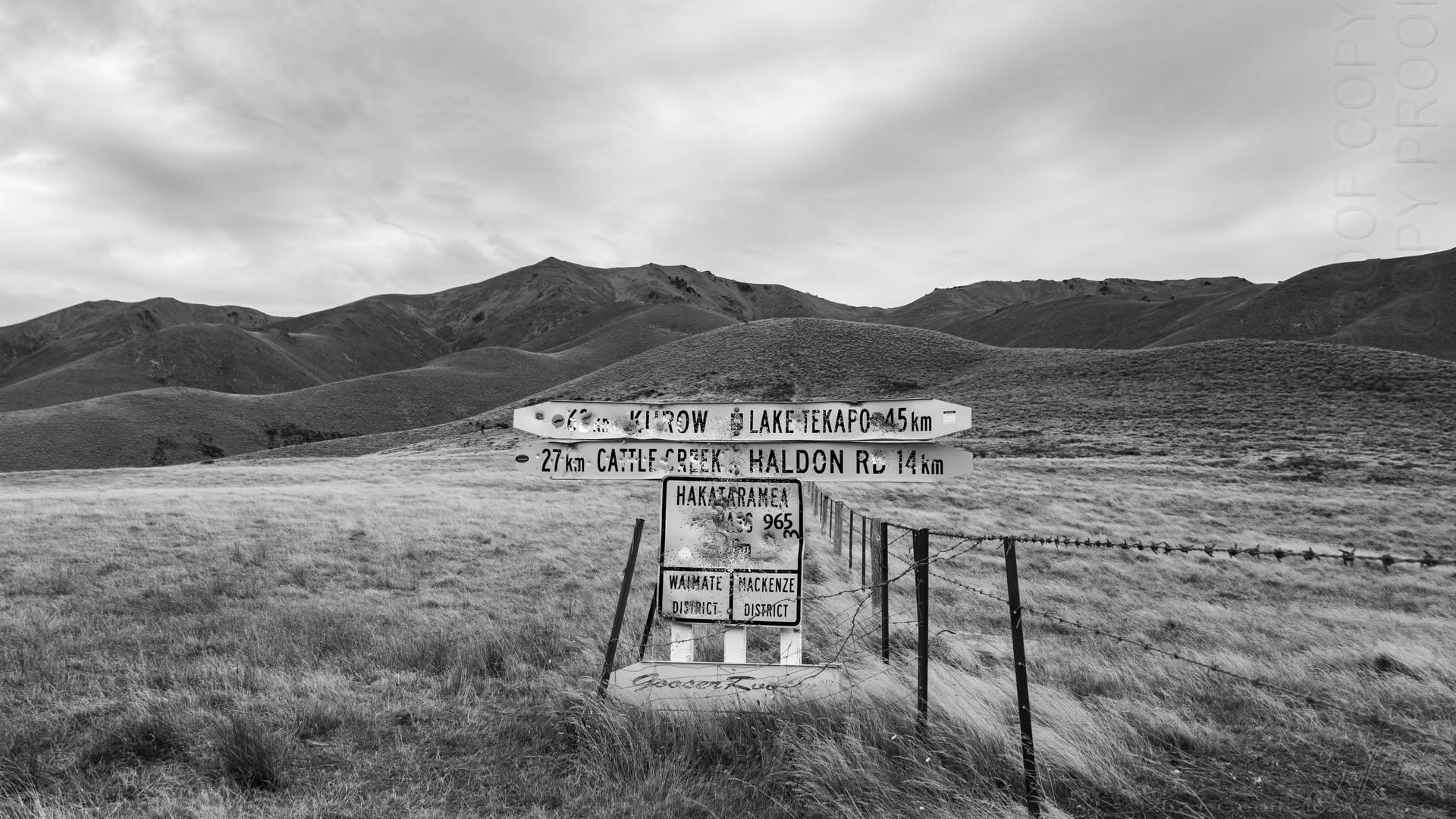
Hakataramea Geoff Cloake 2021
Side quest: Who was Bernice Shackleton?
Now here's something I hadn't expected. The woman encouraging people to explore our South Canterbury countryside was from Waimate herself!
Bernice Elizabeth Shackleton was born there on 14 November 1901, and it turns out she had quite a story of her own.
According to the National Library of New Zealand, Bernice became the first woman to gain a Diploma in Journalism, in 1927. She went on to work for the Christchurch Star, reaching a senior editorial position when newspaper management was overwhelmingly male.
She also reported on Parliament from Wellington, although women journalists still faced restrictions on where they could sit. Imagine being qualified to report on the country's lawmakers, but having to work from a section of the public gallery set aside for women!
And the Waimate connections don't stop there. Bernice's mother, Elizabeth Catherine Tregoning, signed the women's suffrage petition in 1893. Her name appears on sheet 232 of the petition. A generation later, her daughter was pursuing a career in an industry where women still encountered formidable obstacles.
Bernice returned to Waimate in 1939 and became involved in wartime organisations, hospital advocacy and other public affairs. In her eighties, she wrote The Fifth Schedule, a history of Waimate Hospital, and in 1986 received the Queen's Service Medal for public services.
I even found a photograph of her at the launch of her book, preserved through the Waimate Museum & Archives collection.
There's another lead worth pursuing. The National Library holds a recorded interview with Bernice from the 1990s. I'd love to hear her describe her experiences in her own words.
So, I set out to learn about an old tourist road and ended up discovering a Waimate woman who made her mark in journalism and public life. There's something rather fitting about a woman who spent much of her life challenging barriers writing about opening new routes through the countryside.
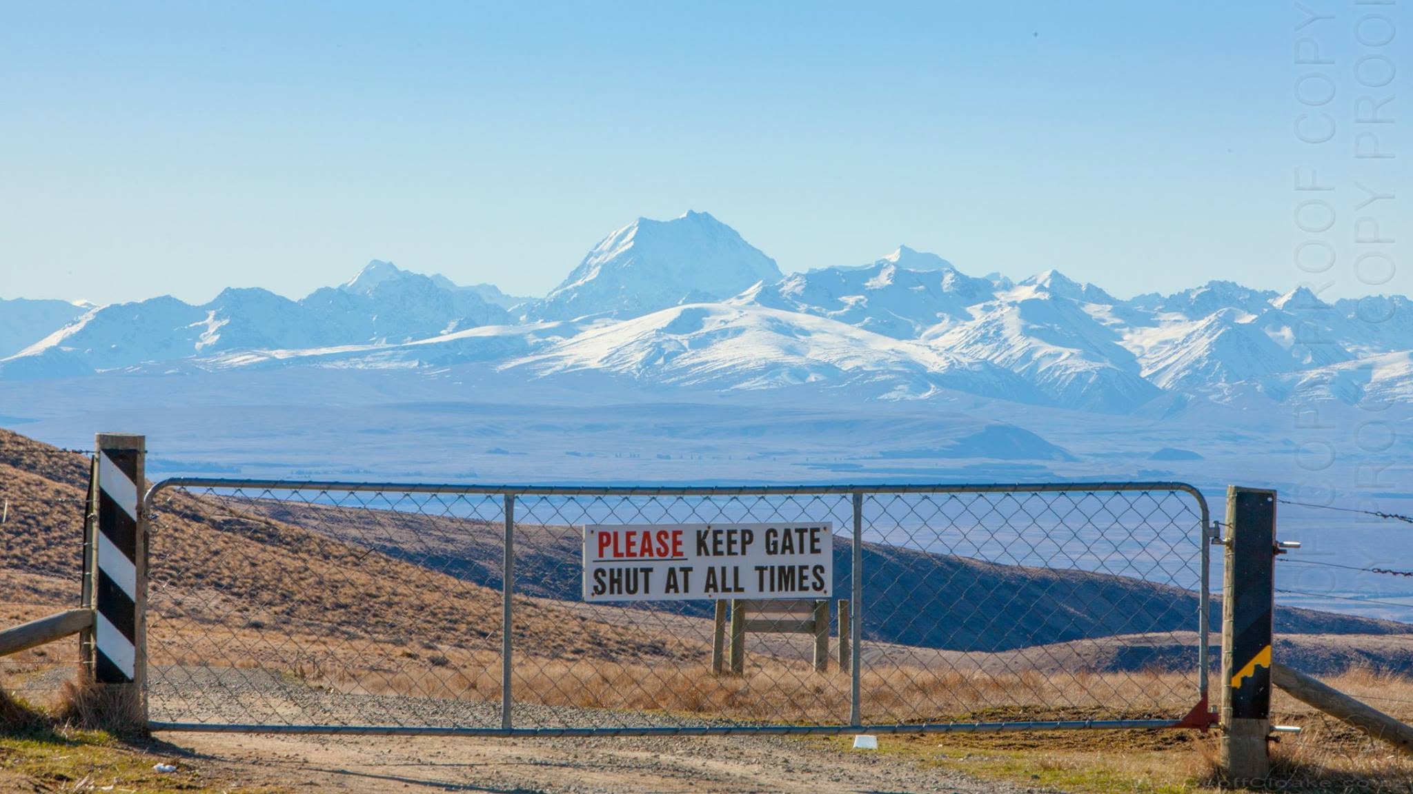
Hakataramea view towards Mt Cook Geoff Cloake 2015
Nearly 90 years later, we're still enjoying the journey
Geoff has photographed Hakataramea Pass and the surrounding countryside on several of our family outings. Looking through his images reminded me just how magnificent this corner of South Canterbury is.
There's the weathered sign at the pass, marking the boundary between the Waimate and Mackenzie districts at 965 metres above sea level. Another photograph captures the golden tussocks and rolling hills of the Hakataramea Valley in 2023.
And then there are those enormous views towards Aoraki/Mount Cook, photographed from a ridge above the pass in 2015. What a sight!
The scenery changes as you travel. Cultivated paddocks give way to broad pastoral valleys, tussock-covered slopes and mountain panoramas. It's working farmland, with stock, fences, gates and roads that demand your attention.
For us, sharing this drive is a lovely way to introduce overseas visitors to another side of New Zealand. Away from the familiar tourist destinations, there's a great deal to enjoy without buying a ticket or booking an activity. And it turns out we aren't the only people who've found adventure along this road.
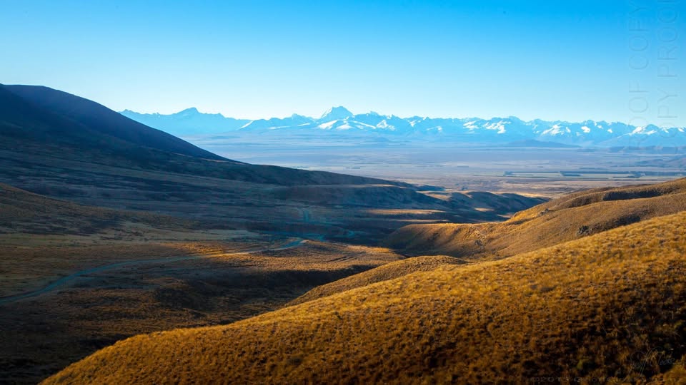
Hakataramea view towards Mt Cook is from higher up on a ridge above the Hakataramea Pass - Geoff Cloake 2015
Three vintage cars and an Easter adventure
While researching the pass, I came across another terrific account. In the June-July 1980 edition of Beaded Wheels, the Vintage Car Club magazine, Bill Mitchell described an Easter Saturday expedition across Hakataramea Pass.
Three vintage cars took part: a 1920 Hupmobile, a 1922 Dodge and a 1929 Austin Seven. Their outing took them from North Otago, through Kurow and up the Hakataramea Valley towards the saddle. On their motoring map, the route was little more than a dotted line.
And there's a photograph of all three cars at the summit!
I had to smile. Imagine tackling those back-country roads in vehicles built more than half a century earlier.
Now we have Shackleton's observations from 1938, a vintage motoring adventure published in 1980 and Geoff's photographs of our outings from 2015 onwards. Different cars, different decades, but a shared enthusiasm for venturing somewhere a little less familiar.
I'd love to identify exactly where the vintage cars were photographed and compare the scene with today's landscape. That sounds like an excellent excuse for another outing.
Read the original 1980 article in Beaded Wheels.
What have we been driving past all these years?
This was where my research took a few unexpected detours. Shackleton wrote about much more than the mountain crossing. Her article wandered through the Hakataramea and Waitaki valleys, the pastoral stations, Waihao, native plants and the origins of place names. The closer I looked, the more I found...
An enormous limestone woolshed
Did you know the Hakataramea Valley has a limestone woolshed dating from around 1868? According to Heritage New Zealand Pouhere Taonga, the Hakataramea Station Woolshed originally accommodated 24 shearing stands.
Twenty-four! The substantial T-shaped building has arched windows and an innovative slatted floor. Recognised as a Category 1 historic place, it continues to serve the farming operation.
Imagine the undertaking of constructing such a building in the 1860s, then the generations of shearers, wool handlers and station workers who passed through it. Who quarried the limestone? Who were the stonemasons? What were the working conditions like?
The National Library holds station records, including financial documents, staff information and shearing returns. There's plenty more to investigate. The woolshed stands on private property and isn't a public visitor attraction, but it's an impressive survivor from South Canterbury's pastoral past.
A stone bridge on another mountain road
Shackleton also described a journey across Meyers Pass, linking the Hakataramea and Waihao districts. Waimate District Council's heritage records identify an old limestone arch bridge on Meyers Pass Road, built in the 1930s or earlier. Was it already standing when Shackleton travelled through in 1938? And who built it? That's another little mystery for a future WuHoo investigation.
Perfume from a prickly plant?
Shackleton also introduced me to taramea, a native speargrass sometimes called Spaniard, whose fragrant gum was traditionally valued by Māori. Perfume from a plant armed with such formidable spikes! She recorded accounts of gathering the gum and explanations of local place names. These deserve further investigation alongside mana whenua knowledge. The magazine tells us what Shackleton understood in 1938, but not necessarily the full cultural history behind those traditions. Still, it's quite an assortment of discoveries to come from one travel article: roads, buildings, women's history, native plants and the stories attached to the land.
Not bad for a Sunday drive!
Fancy taking the drive yourself? Waimate to Fairlie, over the ranges
One of the things I love about this adventure is that you can travel right through the hills from Waimate to Fairlie, crossing both Meyers Pass and Hakataramea Pass. From Waimate, head into the Waihao countryside towards Waihao Downs and Waihaorunga, then follow the rural road network onto Meyers Pass Road. The route crosses the hills before descending into the Hakataramea Valley.
From there, head north along Hakataramea Valley Road and continue over Hakataramea Pass towards the Mackenzie Basin. The road connects with Haldon Road, which leads to Dog Kennel Corner on State Highway 8. Turn towards Burkes Pass and continue to Fairlie. It's a splendid journey through contrasting landscapes, from the green Waihao countryside to expansive grazing country, tawny hillsides and sweeping views towards Aoraki/Mount Cook.
But this is a back-country gravel-road adventure, not an ordinary sealed tourist highway.
Both passes require preparation. Loose shingle, slippery clay, snow, flooding and stream crossings can make sections difficult or impassable. Check that the roads are open, the conditions are suitable and your vehicle is appropriate before setting off.
A few tips from our family outings
- Pack a picnic. Take plenty of drinking water, snacks and warm clothing. Finding somewhere safe to stop and enjoy the countryside is part of the pleasure.
- Allow plenty of time. Leave enough daylight for the journey, photographs and unhurried stops.
- Prepare for shingle roads. Expect loose surfaces, narrow stretches, gates, livestock and possible stream crossings.
- Check the conditions. Snow, heavy rain and rising streams can close the route. Never attempt an uncertain ford.
- Carry offline maps and emergency supplies. Don't rely on continuous mobile reception.
- Respect working farmland. Stay on public roads, follow signs, leave gates as you find them and take your rubbish home.
- Respect private access. Some of Geoff's photographs were taken from ridges above the road, not from public roadside viewpoints.
Check Waimate District Council road alerts and Mackenzie District Council road conditions before travelling.
If the weather is doubtful or your vehicle isn't suited to the crossing, save the adventure for another day. It's a fantastic outing to share with visiting family, and an opportunity to appreciate scenery that many people travelling through South Canterbury never get to see.
Nearly 90 years later, the invitation still stands
Finding Shackleton's article has given me a fresh appreciation of a drive we've enjoyed for years.
Now, when I look at Geoff's photographs, I wonder what those same views looked like when early motorists ventured through. Which buildings have survived? Could we track down the locations of the original 1938 photographs? And what other clues might be sitting alongside the road?
I love that Shackleton was encouraging people to explore this country in 1938, vintage motorists were making their own adventure decades later, and we're still enjoying the route today.
Perhaps what has changed most is the way I look at it... We've admired the views, stopped for picnics and shared the journey with family. Yet one old magazine has given me an entirely new collection of things to look for. And I suspect we'll be heading over the ranges again before too long.
So, if you've got a free Sunday, the roads are open and the weather looks promising, why not pack a picnic and head somewhere you haven't explored before? You don't have to travel overseas or spend a fortune to enjoy something extraordinary. Sometimes you just need to take the slower road. And if something catches your eye, stop somewhere safe, take a closer look and follow your curiosity.
You never know what you might find.
Have you travelled over Meyers Pass or Hakataramea Pass? Perhaps you remember the roads from years ago, have old photographs or know something about the bridges and buildings along the way. I'd love to hear your memories.
Sources and further reading
- Bernice Shackleton, New Roads ... Over the Ranges: The Hakataramea Pass, The Key to Story and Beauty, The New Zealand Railways Magazine, 1 July 1938, pp. 25-27. Supplied historical article.
- Bill Mitchell, A Day to Remember, Beaded Wheels, June-July 1980, pp. 19 and 23. Original article.
- National Library of New Zealand, Bernice Shackleton archival record.
- NZ History, Elizabeth Catherine Tregoning and the 1893 suffrage petition.
- Waimate Museum & Archives, Bernice Shackleton biography and photograph.
- Heritage New Zealand Pouhere Taonga, Hakataramea Station Woolshed, List No. 318.
- Waimate District Council, District Plan Heritage Protection Schedule, including the Meyers Pass stone arch bridge.
- Mackenzie District Council, road conditions and closures.
Photographs: Geoff Cloake, 2015, 2021 and 2023. Historic illustrations credited to their original publications and collections. Reproduction of historical photographs is subject to relevant permissions.
Road conditions can change without warning. Check current closures and vehicle suitability before travelling. This article is a personal account and heritage exploration, not a substitute for current navigation or road-safety advice.